How do you prepare for an activation? How do you plan for it?
As an old man (in the truest sense of the word), I am a friend of paper. I couldn’t read a novel on an Ipad either, it can’t replace the book for me.
For me, the preparation is already part of the activation and a great anticipation. I look in the offered maps, which are deposited with the respective SOTA Summits here or at SOTL.AS, after the access to the respective summit - and I look for:
What is the hiking trail to the top?
Where can I park? (Is parking allowed there?).
How do I get there? Are the roads open or closed to the public? …or snow-free in winter?
Do I have a plan B for access?
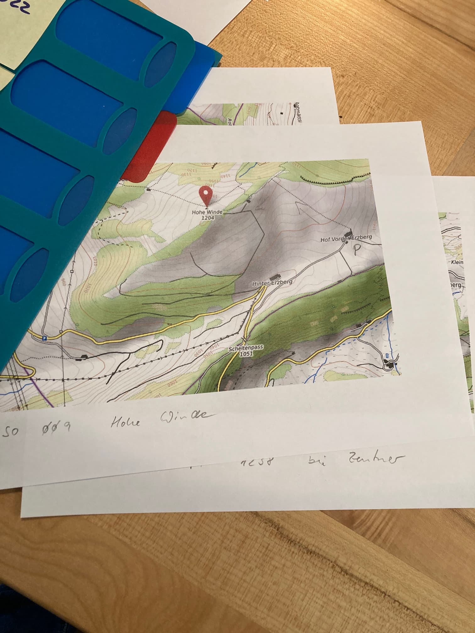
I put this info on paper and print it out … And take it with me on site. This gives me a good orientation… especially if the navigation system does not know the points to be approached.
During the hike itself, I can also not always rely on a network access and thus determine my position in the landscape on the online maps. For more obscure tours I use the app Maps 3D on the Iphone. Since I can download in advance the corresponding map section and can use it together with GPS - offline!
With this preparation I can spend enjoyable evenings… and make plans for individual days or vacation periods.
My next plans are:
To activate the summits around Baden-Baden on June 4, I’ve never been there! (I hope the weather will be even better as it is announced).
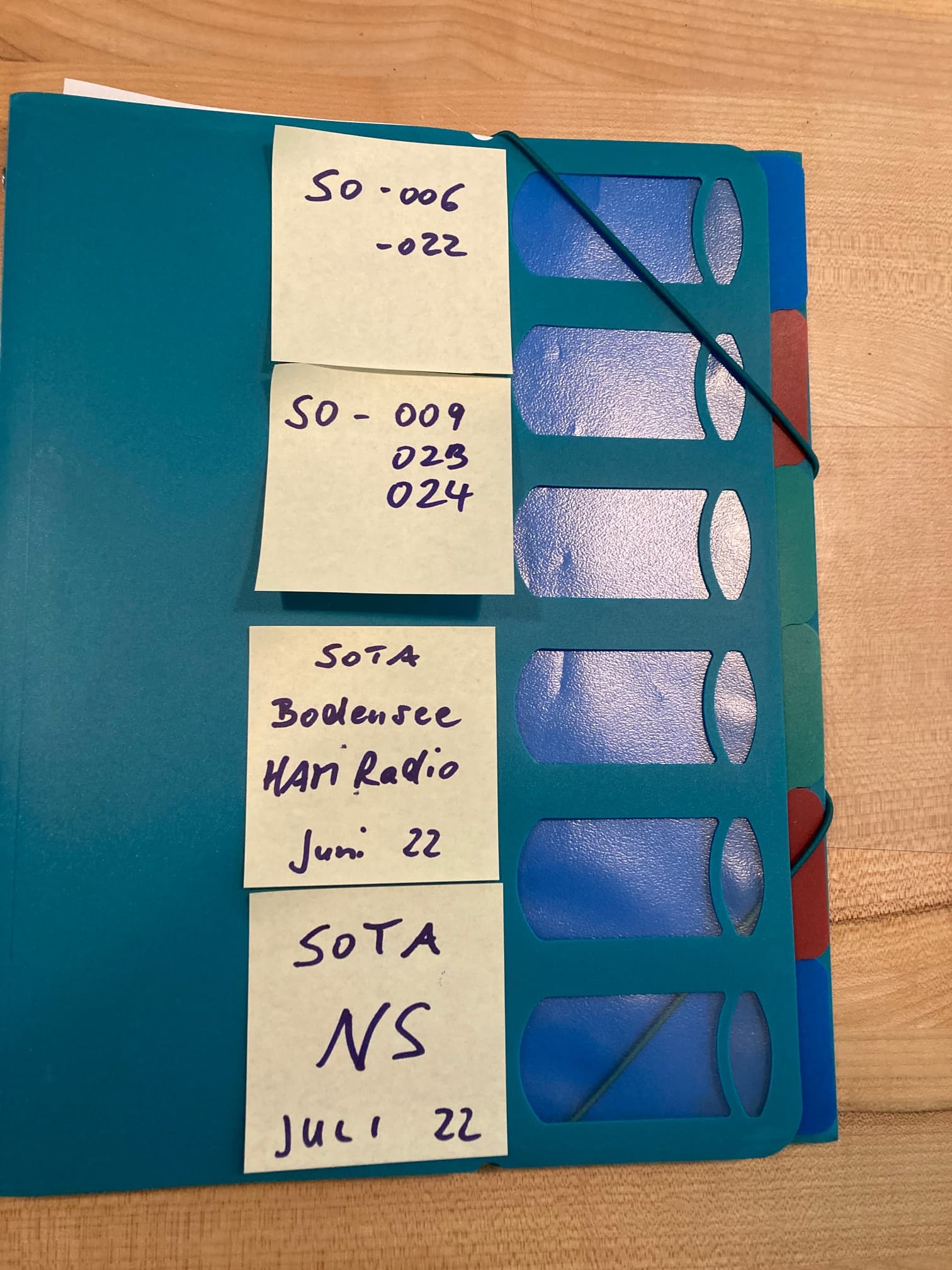
To activate the remaining summits in the canton of Solothurn.
To activate the summits at Lake Constance during my vacation at the time of Ham Radio.
To complete the Summits in Lower Saxony when I am there for a week for my mother’s 85th birthday in July…
I use UK mapping program that has 1:25k maps from the UK mapping agency. Plus Googling for walk reports (walkhighlands.co.uk is good). GPX from mapping site or elsewhere. Google Streetview for parking opportunities.
Route into GPS. Paper map printed into Ortlieb case. Bag remains packed mainly all that is added is logpaper, more chocolate, fresh water. Maybe change antennas taken. Fleece, jackets etc. picked when leaving car.
Climb hill, enjoy countryside, be the DX, smile because I’m the DX, descend hill, drive home, enter log. Then rinse and repeat as often as possible.
Hi Armin,
Like Andy I use a hiking app (Alltrails, GAIAGPS). After that I rely on past experience. I use the free version of Alltrails. My app’s direction feature gets me to the trail head, the rest is all motivation.
I keep my pack loaded with seasonal gear and seldom do I plan ahead. I typically find myself looking at Summit Information on the SOTA website just before leaving the house. Some like to plan, I tend to be somewhat spontaneous.
GL es 73,
fred
Meticulously! Most of my outings start with a long drive, so timing is an essential factor in planning. I always research the best options for the ascent route, parking, etc. It becomes more onerous when the day involves multiple summits - the more summits, the more planning is required and the more complex an itinerary I prepare.
As Andy says, we are spoilt here in the UK with excellent mapping and a wealth of information on sites such as https://www.walkhighlands.co.uk/ and https://www.hill-bagging.co.uk amongst others. Why reinvent the wheel when tackling a hill or mountain? It is better to read how others have accessed the hill, be prepared for any pitfalls and in the execution of it, still manage to get it wrong despite carrying map, compass and GPS!
Often I find the car parking challenging. What some people regard as a parking spot certainly won’t accommodate my car. Perhaps they drive Smart cars. I tend to use Streetview to check out the parking. The last thing I need is hassle after a 300 mile drive to get to the summits. The 6P principle applies in all instances. I have a large lever arch file dedicated to planning outings.
As for the longer term, my next goal is 2X Goat, so I am planning to activate some of the higher summits during the summer, leaving the 2 and 4 point summits for the winter bonus period. Hopefully this way I will achieve my goal before I have to hang up my boots.
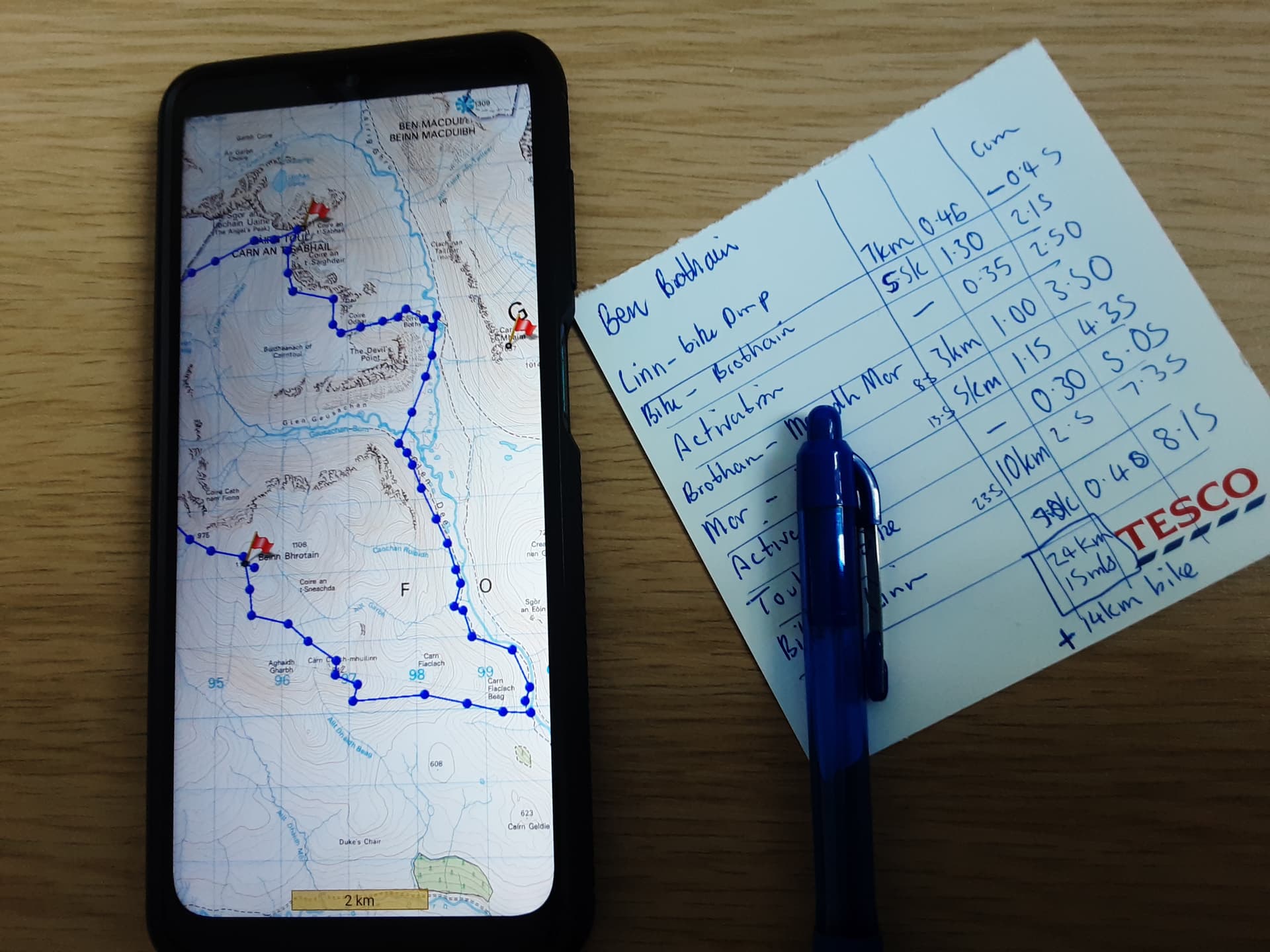
For anything more complex than a short walk to a single summit, I’ll draw up a route on my PC, or in todays case, on my phone at lunchtime. I’ll work out individual legs, add activation times and jot it all down on a route card.
I usually start with the Solt.as website to find summits that I have not activated - or preferably will be a complete. There then follows some faffing around with a combination of google maps to estimate the driving time, the OS Website with 1:25000 maps (Their route planning timing usually is about right for my rate of ascent) and walking reports on either the SOTA reflector or a walking website and finally Google Maps again to work out if I will be able to park the car. I often have several different alternative routes investigated before I finally make my mind up, which is often based on car parking as much as the walking! The now rather old reports from the man who was in a boat often give me an idea of the difficulty walk measured in units of soup consumed…
By the time I actually start the walk I have usually looked at the (online) map in quite a lot of detail and it is often mostly committed to memory, so although I carry a map it is now unusual to use it, with a glance at the map on the phone usually enough to confirm the route and depressingly the ascent still required. So a different approach here - routes carefully researched but often only a paper back-up. When I was planning the holiday on Mull I spent quite a lot of nights planning routes and had about a dozen planned with start points and routes saved on Evernote - I actually managed three…but it was a family holiday.
The bag is often mostly packed but the KX2 goes from the desk into its case, and that in a waterproof bag, there is a slight variation in antennas taken but usually a 2m J pole and then either an efhw (40m, 20m) or (20,17,15 (linked)), or linked dipoles (80,60,40) or (60, 40,20,17,15). The final choice of kit takes place as I park the car, with things being removed from the rucksack after I have lifted it! I must admit enjoying the planning and researching the route, and to maintain some sort of domestic bliss I do plan timings, the drive usually being a substantial part of the event. 73. Paul
Using SOTL.AS to find these summits and get information about the trail and situation on the summit (if available). For many summits in some areas I found such Information also on hikr.org. The best maps for Switzerland I’ve found on map.geo.admin.ch.
Using Google maps at home for the route to the start point of hiking and the Satellite view to find places for parking. On the road I’ve support from my classical navigation device.
During the hike I use Android Locus (free version) with local stored maps (with very detailed information for hiking). In case of difficult terrain as a backup I print a map and put some comments on the plan.
My most ambitious plan was the Shetland Isles in 2017. 19 summits on 8 islands in 8 days. I failed to visit SI193 on Fair Isle, no time. The 18 summits I managed included 9 ferries of which most had to be booked and 2 flights.
Challenges:
Some days, 3 activations, with a car journey and more than one ferry in between each
Unknown ground and roads
Specific pre-booked ferry and flight times.
Specific times for some activations
That mantra, “Never leave the pileup”
There are only 24 Hrs in a day and I have always had a need to sleep.
As several people have said, planning their exped was an exciting part. I absolutely agree.
I also used a lot of paper, two copies of the 25000 map for each hill, one for me and one back at base. Each annotated with route and parking spot and sealed in a plastic bag.
A spreadsheet for each day covering, departure time, arrival time, Satnav details of ferries and parking spots, ferry times, summit ID and GPS info, road head parking Grid Ref, parking time. Summit arrival time, leave summit time, arrive road head time, all repeated for each ferry and activation. Being on spreadsheet it was easily modified. A copy of the spreadsheet remained at base.
I drove everywhere by satnav. Prior to going to the island I had used Google earth to check the location and suitability of each road head and summit. It was a strange sensation to rock up at a spot I had seen before on Google earth.
I very much enjoyed the whole planning/activation experience, but never again, that was a one off. Some of the people back at the bunkhouse in Voe never saw me, I would be off at 0500 and in bed by 2100 having showered, eaten and uploaded my logs.
First I look for the place in SOTA Maps,then I try to read the stories of EA2IF,EA2BD and EA2CW or others if there are any information.This leds me to know a good information of the access and time to reach the selected summit.
I work wiith Osmand APP.Once I have studied the information of our coleagues I locate the summit in the Osmand app.
Recently I am trying to learn how to load the GPX tracks in Osmand althoug Osmand by itself helps a
lot.
The day before I try to get the battery ready and the backpack with everything.I always miss something!!!
I also start with sotl.as. Using that and other maps (google, SwissMaps, …) I print a cheat sheet for the summit on double-sided A5, front side with summit details, backside the broader regional overview (highway exit, parking place, public transport, …).
On the hike, I use OpenStreetMap for Android (OSMAnd+). The paid version lets you download for offline use as much as you can store. I use this for hiking as the maps are excellent and available offline. Online maps let you down in the most unexpected places (I would have thought that Switzerland has mobile coverage almost everywhere, but sometimes there is just nothing or I am already in France or Germany (or at least my mobile phone thinks so)).
Usually I make sure to have a fully charged mobile phone, but just in case I have an USB torchlight that also serves as powerbank.
73 de Martin / HB9GVW
PS: The summit cheat sheet is amended after the activation with remarks (best position, restrictions, ideas for subsequent activations, …).
I surprisingly do the same as you, I use Sotamaps do include the route I have decided to follow and screen dump to a printer, on that piece of paper I write the Summit Ref and name. I also add the Grid Locator, Postcode and WAB Square to the paper map.
My activation also includes a long drive especially these days looking for a unique I haven’t been up before.
During the hike, I will use the OS paper map and compass along with a Garmin GPS and also as back up an offline downloaded map on my mobile.
Good luck with your future plans to activate this eregions and summits that you have mentioned
As others have said, planning is part of the fun! It is always a great moment when plans and reality finally merge.
This was especially true as the ship slowly approached the port of Honnigsvag, in the very north of Norway, and I saw Storefjell , LA/FM-386, for the first time.
I had studied the area on maps and even watched the local web cam for quite a while, and it was awesome to combine the image in my head with the real summit.
While the ship was in harbor, I had only 3 hours to complete the activation of this summit, which was - for a short time - the northernmost SOTA summit ever activated.
Like many others, I also use SOTAmaps, SOTL.as and reports / tour info from other activators. For new summits for me, I look in advance for parking and a suitable route to the summit. In a small notebook which I always have with me, I occasionally write down important information which I can then retrieve. With well-known summits I try gladly times new ways. Here in the Black Forest, however, the planning is limited because all paths are actually well marked and you can not really get lost. Of course, you should always have the final coordinates in view. And yes, planning is part of the fun
Same as Marcel myself, almost - SOTAMaps, SOTL.as, Locus maps LoMaps (I am now using Locus 4 with web planner support synced to my phone), Google street view and then pre-programmed car satnav by lat/long, for parking precisely. I then produce a spreadsheet when a multiple summit tour is involved displaying Summit ref, Summit name, Points, height, parking ref, Walk length, ascent, Estimated QRV time, Comments, Drive time to get there, Distance to drive from last parking place.
As I am usually the navigator on the tours I do with Victor GI4ONL (the driver) latterly I try to update the arrival time on the alert via SOTAWatch 3 before we leave the vehicle to help the chasers who may be monitoring the alerts for our expected time. Like others, planning the mission is also enjoyed!