First SOTA activations of BEN LOYAL (GM/NS-052) and BEN HEIL (GM/NS-103), using SSEG Club-call, GS0OOO/P and own call.
All times BST (UTC plus 1hr, UOS) on 15-May-07.
The XYL was keen to have a holiday, away from cooking, dusting and another succession of funerals. She knew I would readily accept a trip to GM. We had been to Dornoch in February 2005, so we duly booked in again. In a fair exchange of castles and coffee shops for SOTA’s, she & I could proceed.
I spent a week or more preparing various routes and maps for a broad range of possible SOTA targets but I have had a fondness of Ben Loyal since my (then) 13 year-old son Andy & I climbed it in 1995 from the banks of Loch Loyal.
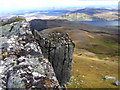
Certainly, it is difficult to see how anyone could not be captivated by this hill, rising from its flat surroundings, with its unique appearance from every direction and a ‘castle’ on top. Our May 1995 approach was pathless and involved the ‘pointless’ climb of a gully on the shear east face of An Caisteal (‘The Castle’) where the trig point is located. ‘Pointless,’ because circling round this feature to its ‘rear’ (west) side enables an easy ascent. Then, we saw many lizards and managed to locate the remains of Handley Page Hampden Bomber P2188, which crashed on the steep eastern side of Sgor Chaonasaid, Ben Loyal’s northernmost top, on 25th of August 1943.
A little research soon uncovered the accepted northern route, along a track then a path from Ribigill Farm, past the deserted Cunside Cottage. There is room for 2 or 3 cars where the private farm-road starts at NC 5843 5470 but you can’t take your dog on this hill because of the Red Deer.
The WX forecast was poor for the week; the best day being the one after driving over 400 miles up to Scotland. Not ideal. Left Dornoch for the 75 minute / 61 mile drive along frosty roads, at a ‘breakfast-missing’ 06:10 and started the walk at 07:45. Today was to be split between SOTA and aircraft archaeology. In 1995 we had fixed the Hampden position by triangulation and one objective was to check it using GPS.
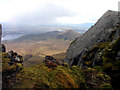
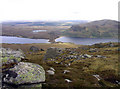
The walk-in, mainly over grass and peat, is straightforward enough but a shallow stream must be forded at NC 5808 5157 and the path is boggy for some distance either side. A little after Cunside, which the route skirts to the west, the ascent begins. I had to leave the path at NC 5861 5002 to look for the wreck-site on steep ground, so I can’t say whether it goes to the summit or not. I started to climb past aircraft parts at NC 5843 4984 but may well have missed some lower down. Hampden on Ben Loyal with Ben Hiel in... © John Earnshaw :: Geograph Britain and Ireland The undercarriage was marked-in at NC 5836 4975 but I didn’t find the larger section we had seen last time. After this, a flatter area is attained and from here can be seen the high point An Caisteal, masquerading as a modest rock, apparently nearby but in fact still 1000m distant and of deceptive scale.
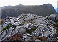
It wasn’t too windy so I used the umbrella to fend-off showers of sleet or hail as I re-located a path at NC 5779 4911. An Caisteal’s rock plinth, upon which stands the trig point (GPS’d as NC 57810 48856) was accessed from the northwest away from the danger of the vertical eastern rock face.
BEN LOYAL, GM/NS-052, 764m, 4pts. First activation for SOTA. 10:25 to 13:17 BST, 2 deg C (later 5C) snow / hail showers / sunny periods, westerly 20 mph wind. WAB: NC54. Loc: IO78SJ.
The only refuge from the weather was behind the lip which overlooks the gully on the east face, with the dipole just fitting-in N-S. Initially (on the off-chance) I tried calling G4JZF and G0NES on 5 MHz ch.FE but quickly migrated onto 7.032.5 CW working 27 stations there (including Don G0NES at QRS) using 10W, with the brolli fending-off the ‘white stuff.’ SSB was a lot more difficult and costly in terms of battery current with power increasing to the 70W level in a lot of cases, putting in jeopardy, the prospect of second summit. Another 20 QSO’s were logged on 7.057 from 11:20.
Conditions on 40m were not brilliant but two CW S2S’s were worked with Alain F6ENO/P on F/NO-008 and Joachim OK/DJ5AA/P on OK/US-006? ‘Standing-back’ an extra 450km, compared with the local summits I normally activate, 40m was ‘stretched’ and just barely ‘delivering’ as far as HB. However, it enabled me to work in as close as Inverness. I just hoped that there wasn’t an extensive skip-zone because I did not now have sufficient resources for another QSY, perhaps to 80m (and/or 30m.) By noon (UTC) the stream of callers had ‘dried-up’ and attention turned to the next and final target.
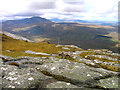
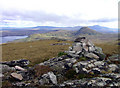
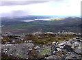
The walk across to Ben Heil took about an hour. Its SW face can be climbed almost anywhere but a natural line via NC 5907 4975 and NC 5929 5003, suggests itself. The surface consists of grass with heather and rocks interspersed and the top is marked by a cairn alongside an ‘80m-dipole-sized’ grass area with a southerly inclination.
BEN HEIL, GM/NS-103, 534m, 2pts. First activation for SOTA. 14:20 to 15:55 BST, 7 deg C, sunny periods, NW 15 mph wind. WAB: NC55. Loc: IO78TK.
The gently-sloping open space just south of the cairn makes setting-up an E-W dipole easy. Cris GM4FAM, immediately responded to my ‘QRL?’ on 7.032 CW but during the seventh 5W QSO with Pete EI7CC, the power-greedy IC706 had ‘gobbled’ the remaining power from the 7.5 Ah SLAB and the rig began to cut-out. What remained; a 2.7 Ah AA pack, was not going to last long when mated to a 706 but by limiting the power to 5 or 10 Watts, another 10 CW QSOs were completed.
SSB on 7.047 should have resulted in 7 more but try as I may, I could not succeed in delivering reports to Mick and Steve (2E0HJD & GW7AAV). The AA pack went flat as the frequency seemed to ‘dry-up’ but at least it had made 15 QSO’s possible, though it could not provide current at sufficient voltage, for outputs much above 10W. With hindsight, I may have been better off with the QRP FT817; no battery worries and what’s more, no aching shoulders! However, mediocre band conditions may not have allowed any greater success and 5W of SSB from NS52 in the morning would have been even more difficult.
I have often mused that ‘empty’ batteries should be lighter. In fact anything that’s useless is much ‘heavier’ and I now had to get this heavy rucksack back to base. It took me until 17:10 to reach the car but I was back in Dornoch and straight-in ‘unwashed’ for an evening-meal by 18:32.
I confess, the combined aircraft-wreck and two SOTA route of 15km and (750 + 220) 970m (3182ft) of ascent had left me quite tired after doing nothing much for the past 2 months. In some ways, carrying QRO was a mistake but at least it was a cool day. With QRP and a lot more time, GM/NS-096 might have been addable but this would likely have necessitated a sortie-in from Loch Loyal, resulting in more difficult terrain but with the advantage of a higher start-point and the possibility of an extra band.
QRO kit: IC706Mk2G, 7.5 Ah SLAB and 11 x 2.7 Ah AA pack in reserve. Link-dipole in inv-vee config. 5m mast AGL / 1m end-supports. Jingtong 2m FM H/H as backup. Garmin GEKO 301 GPS. Pack weight 13.6 kg (30 pounds).
QSO summary:
Ben Loyal, 40m band: 27 CW & 20 SSB = 47.
Ben Heil, 40m band: 17 CW & 5 SSB = 19.
Total: 66 QSO’s.
Battery utilisation:
7.5 Ah / 2.7kg SLAB: 100%.
2.7 Ah, 11xAA Ni-Mh: 100%.
123 miles round-trip from Dornoch (which is a 406 mile drive from Scarborough.)
Thanks to Roy G4SSH/A in Fowie for liaison and to all who monitor, spot and chase.
73, John G(M)4YSS,
using SSEG GS0OOO/P.
(Entered under GM4YSS/P for SOTA purposes)