I know its a long shot, but worth an ask ![]()
Not quite in your criteria, but GM/SS-066 (Green Lowther) is an easy 4-pointer. Even quicker if you have a bicycle with you.
In Scotland, to drive on a private road you need permission from the landowner. There is no legal right to do so without landowner permission. In some cases, the roads are access roads to NATS radio / RADAR sites or military sites or commercial sites. It’s not always in the private landowner’s remit to grant vehicle access as they may have ceded some of their rights to the people they are renting to.
Slightly OT: When I was contesting in England we used Cyrn-y-Brain. It has BBC, BT, private and MOD compounds on the summit. We needed permission from the land owner and we needed to show that to the BBC who gave us permission to collect their key from where it was kept. We could unlock the gate then drive to the top up the scary road.
And there’s Saxa Vord which has a billiard table smooth road. It’s where I learnt the difference between closed RAF RADAR station and an active RAF/MOD remote comms station. I had to do my best smooth talking “I’ve come all this way please can I play SOTA…” act. It has a very healthy, very active L-band RADAR now.
Not quite. None where you can commit the ultimate SOTAsin and operate from your car. ![]()
No plans on SOTAsinning, just to quicken the activation
Here are two easy ascents that I’ve done a number of times when going up to Glasgow on the M6/M74 and are a short drive up the A702 (Edinburgh road) from the M74 Abington Services junction.
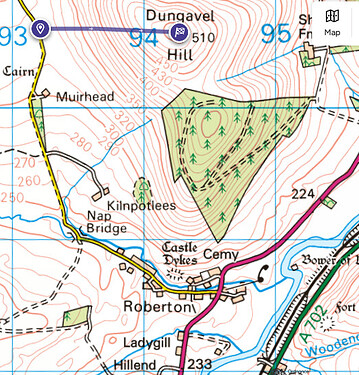
GM/SS-165 Dungavel Hill - take the A73 (left turn) off of A702 and then left on minor road at Roberton. ~35 minutes grassy walk, no real path.
(C) Ordnance Survey 2024
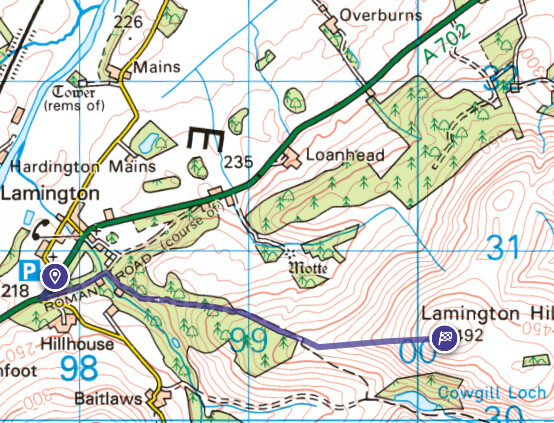
GM/SS-172 Lamington Hill - ignore the A73 turn off, continue a mile or two on the A702 to Lamington village. - ~65 minutes walk

(C) Ordnance Survey 2024
cheers
Lamington is by far the better of the two hills. There’s just something “nice” about it.
Totally agree about Lamington… one I’d walk up again and maybe will do when Paul G4MD gets back into the fray. ![]()
Hi Paul,
I went up East Craiglockart hill (Non-SOTA) to chase you this morning.
I could hear you on 145.500 as I got to the top and switched to 145.550 as you requested but it seems you couldn’t hear me. I had a brief chat with Christine GM4YMM who had also been calling you without success.
Were you near the trig point or closer to the radio towers ? I did my first activation there leaning against the trig point and the second one with the link dipole set up on the ridge about 40 yards away.
Hopefully you got enough QSO’s.
Andy
MM7MOX
No, I heard yourself but not enough to qualify as a QSO and I did hear a female voice but no joy. I’m guessing the mast was just obscuring everything. The two calls I had were very broken. I’m guessing I need a band pass filter for that peak. I was using a slim Jim and a tape antenna. Thanks for trying though.
Thanks all for the replies. The plan is now to look at activating a hill or two (if permission granted from Mrs Vaz and WX OK) on the way up in South Lakes and then Friday, go straight to Arthur’s Seat (just awaiting in official approval from HES) and activate that hill.
Cheers
John
Another go at this - I had to raid the archives:
An old resource that is still useful but may possibly need some updating,
Well done Brian. I knew there was at least one in SS.
Thanks Brian, that is a really useful resource which might help me to get activating again sooner than expected ![]()
This above website has not been maintained now for quite a number of years now and it has been archived also. Therefore, some details regarding some of these “easy SOTA summits” maybe out of date.
Therefore, I strongly advise anyone wishing to activate an easy SOTA summit to carry out their own research for the most updated information and not just rely on this archived website for “easy SOTA summits”.
Jimmy M0HGY
G - Association Manager
Yes, a good “heads up” that Jimmy. Just had a glance and a lot of information is out of date or no longer relevant. For instance, Winter Hill G/SP-010 has not been a drive-on for a few years. And having been there recently, I’m not convinced you can get a vehicle within “20 feet” of the summit of Mynydd Bodafon GW/NW-071 these days.
I mentioned that it “may possibly need some updating”, and it is unsurprising that it does after a dozen years, but it remains a valuable resource and I would suggest that it should be updated and then preserved in an accessible form.
The questions is when and if it can be updated. It’s only accessible via Google’s “Wayback Machine”; I don’t think it’s a live website, and hasn’t been for a considerable time.
We have tags available for every summit in the DB. The options are
Drive Up Summit (Activation zone can be reached by vehicle)
Drive Up Summit - 4WD only (Activation zone can be reached by vehicle with 4WD capability)
Public Transport (Trailhead or Activation Zone can be reached by public transport from nearby city)
Cycle Friendly (Activation zone can be reached by bicycle)
Disability Friendly (Summit is accessible to all people, regardless of ability)
Easy Walk (<30 minutes) (Activation zone can be reached by walking less than 30 minutes from a trailhead)
Moderate Walk (30-90 minutes) (Activation zone can be reached by walking between 30 minutes and 90 minutes from a trailhead)
Long Walk (1.5 hours - 6 hours) (Activation zone can be reached by walking between 1.5 and 6 hours from a trailhead)
Overnight Hike (Activation zone can be reached by overnight or multi-day walk)
Remote or Difficult Trailhead (Trailhead access is remote or difficult and may require 4WD or other special techniques to access)
Rock Climbing Required (Activation zone requires rock climbing to reach)
Potential Access Issues - Please add note to explain
What’s needed is someone to update the tags for the summits in question SO THE DATA IS SAVED WITHIN THE SOTA servers and not left to suffer bitrot and die on some 3rd party website.
