This summit is on private property to the best of my knowledge. However, I do know someone who lives up there about 1000’-1200’ away from the summit. I’m 99.99% sure I can get permission to operate from their property.
I had two questions regarding this:
Would operating near the summit as such count as a SOTA activation?
The summit is on the border to W3/SV, and that property would technically lie in that zone. Would that be an issue to a proper activiation?
I’m brand new to SOTA, but I figure I have an opportunity to get a summit finally activated. Any advice would be greatly appreciated.
Hi,
As long as your friend’s properties at the summit remain sufficiently inside the AZ (Activation Zone) for you to setup your portable station inside this AZ, I don’t see any problem with what you seem to be willing to do.
Good luck!
73,
I suggest you go and read the SOTA general rules and also the specific rules for the region you are going to activate (W3).
Pay particular attention to the bits about prominence and activation zones which will allow you to calculate the locations where valid activations can take place.
Plus, use the tracker tab in SotaGoat to see when you get into the AZ and which direction is the top. That helps whilst trying to avoid stopping at a false summit.
Please see In The Zone - Part 2 (and Part 1) where I give a thorough explanation of the Activation Zone. Short explanation - if there’s no way you could, even theoretically, walk from the summit to where you are without dropping more than 25m (82 feet) you are outside of the AZ. Note that doesn’t just mean being no more than 82’ lower in elevation. An adjacent rise the other side of an 82-foot dip is not valid. There is no horizontal limit. There are AZs that are literally miles across!
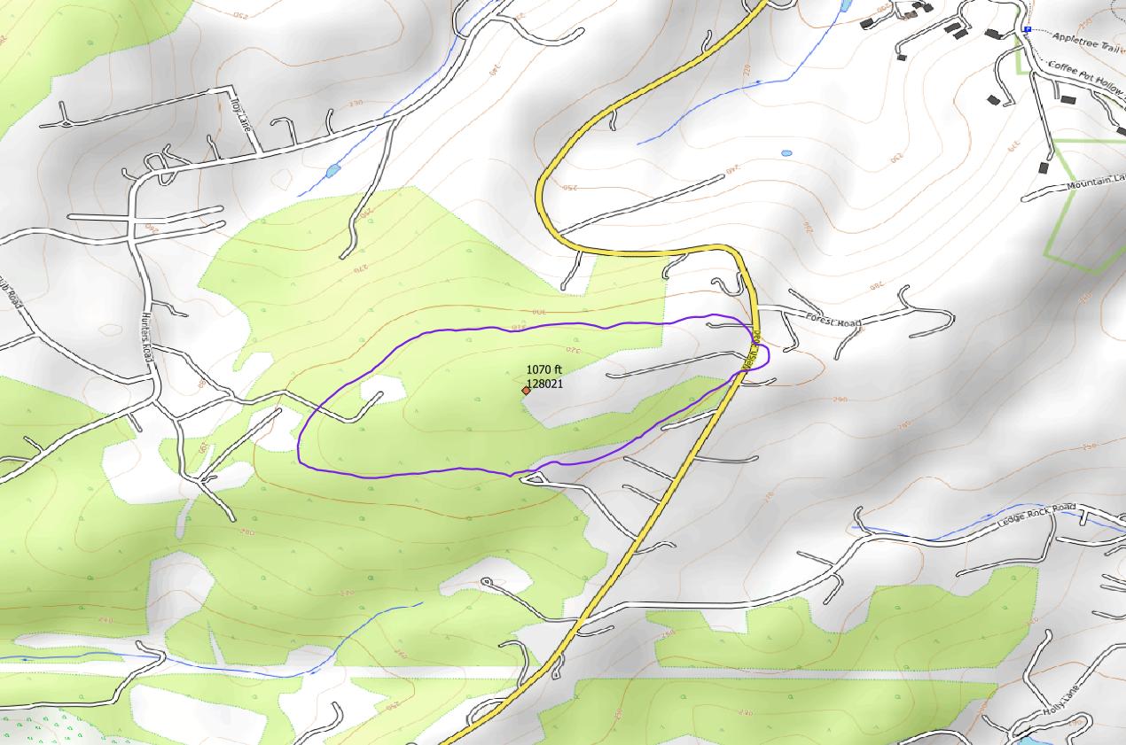
Looking at the W3/PH-006 summit page and following the link to CalTopo it seems to be a simple one. (I shalln’t paste an excerpt as I’m not sure of the legalities)
Listed height is 1070’, so the edge of the AZ is the contour surrounding the summit 82 feet lower, at 988’. Without taking a guess at exactly where the 988-foot contour would run to play safe would be to stay uphill of the 1000-foot contour. But maybe that T junction about 250m east of the summit is just inside?
Don’t rely on reading your 988-foot limit off a consumer GPS (usually wrong, not least because most often they read ellipsoidal height, never mind the noise) or pressure altimeter (maybe not so bad if you can calibrate at the actual summit and walk down, or some other rock-solid nearby calibration point).
We have summits with AZ spanning even national borders! In that case you would just take account of changing jurisdiction (vary your call sign, obey local spectrum regs), but for W3 → W3 of course that is of no consequence.
Thanks for all the replies! I’ll dig into the reading and report back. From a quick glance, I think their property will top out around ~ 970’, which will just be shy.
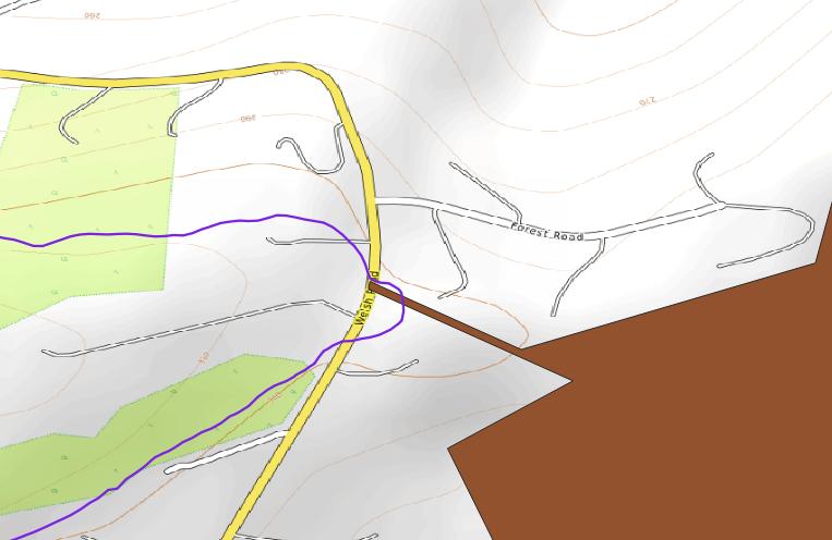
The county parcel viewer is down currently, but once that’s back online I’ll dig into the property lines and see what’s feasible. @G4TJC I do see what you’re talking about. That’s a driveway, but right across the street is a sliver of state park owned land that carries downwards into Nolde Forest State Park. I’m acquainted with that added tract of land. I’ll have to investigate if that is within the elevation range since it doesn’t dip too much down across the road. I do have a higher end Garmin GPS running watch, but I know that still won’t be exact. I’d rather be above 1000’ like you said.
Much appreciated. Their property is below the line for sure, and All property near there is private. That will be a few days to reach out to my friend and see if their neighbor behind them is cool with me going back that way… I’m still leaning on the plan B of the little bump out there on the right, just as that crosses the road. I still think that’s right on the sliver of state park land.
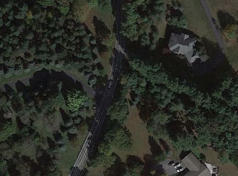
I would say the AZ limit is the road. The vegetation on that strip of public land looks to be dense deciduous trees bounded by private yards… I have had mixed success asking for permission to enter private property to occupy a summit. Looking at the aerial view of the summit, it looks like an estate with a front yard pool with a view rather than some remote backwoods ---- so not likely receptive to SOTA in their backyard. 73! Mike, WB2FUV
I hear you on that. I only will go as far as I have permission to do so.
@G4TJC I have traveled on that slice of state park property. It is hikable, and I’ve taken it down to Nolde Forest State Park. Like you said though, it is rather narrow, so either an end-fed or vertical would be best if I were to set up shop there. I’d have to go over and scope that out some more.
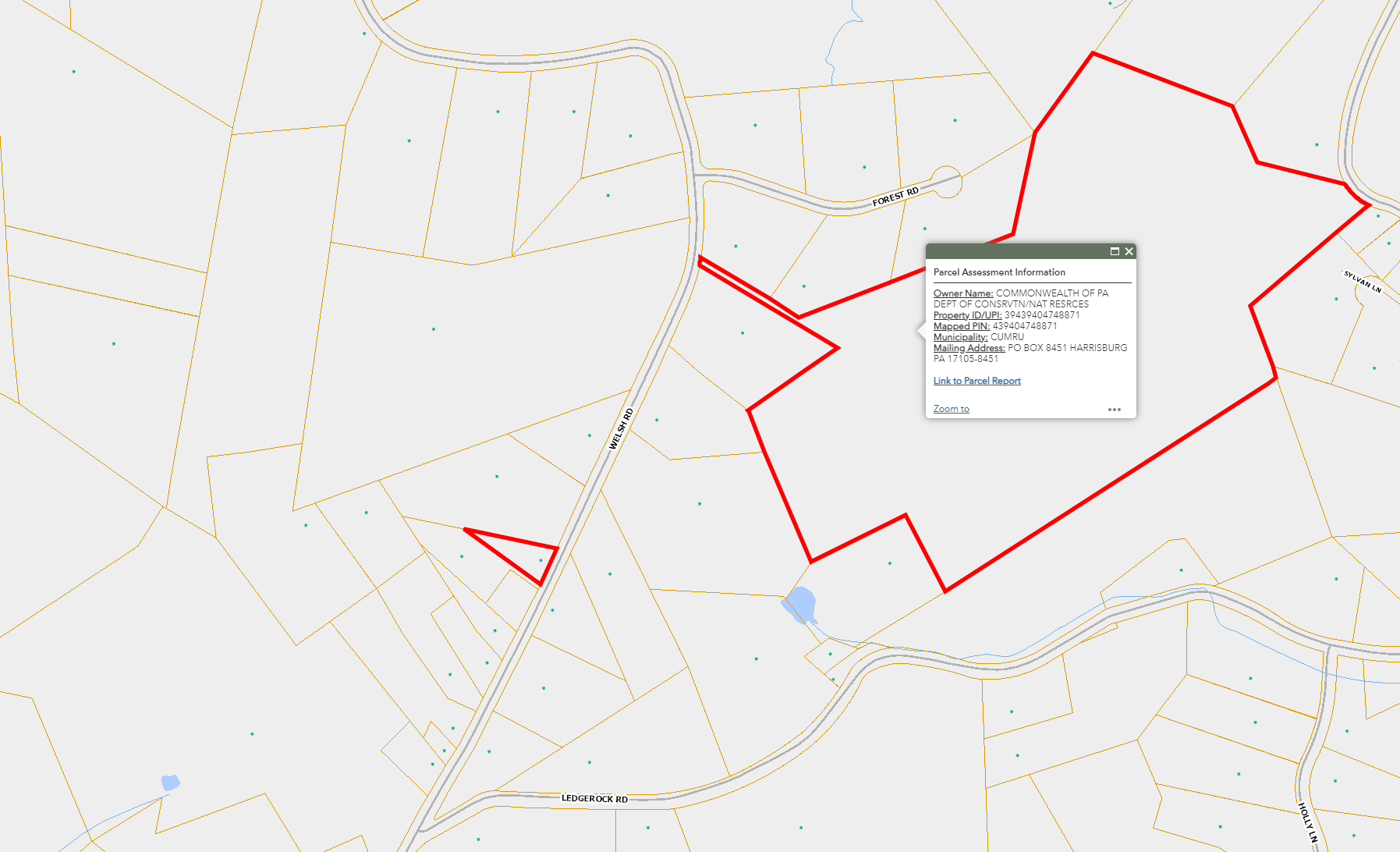
Below is the county property map. The small triangle is the property I would have permission to transmit on.