I trust the RHB in their decisions from their survey results and I always respect their decision from their finings. They were confident from their findings that Cheriton Hill G/SE-015 is no longer a Marilyn so will soon therefore no longer be a SOTA summit.
However the RHB did survey Cliffe Hill G/SE-014 and they did find the prominence for this summit to be less than 150m also, but due to lack of accuracy they decided to keep the Marilyn status for the time-being which is why there are no plans to delete this SOTA summit. If the RHB do decide that Cliffe Hill G/SE-014 is no longer a Marilyn, I will like every other time when the RHB have made these decision to honour it and set a date for this summit to be deleted.
I think there’s bits of grass poking through the concrete banks of the covered reservoir on Cheriton Hill - so I guess it could make a comeback someday.
Ron - we have the nation’s very best surveyors independently maintaining the P150 lists in the UK associations. That’s good enough for me. If it’s not good enough for you, the please drop them a line and offer your expertise.
Notwithstanding my playful suggestion [post #6 above] - poo-poo’d by some as invalid - I don’t actually care whether or not G/SE-015 is demoted, but the subsequent discussion raised some interesting points.
Even if we ignore or dismiss VK3AFW Ron’s point about the uncertainty in LIDAR measurement [which I don’t] we have the problem of ‘the lower end’, i.e. mean sea level (MSL).
If we were measuring heights with regard to the centre of the Earth then Mount Chimborazo in Ecuador would be higher than Everest, but we’re not. So, the question is, which MSL? So, although satellite altimeters can make precise measurements of sea level, depending on which point around [for example] the UK coastline is chosen as the reference, we can get very different results. Two summits [depending on which side of the country they are on] could swap over being the taller. Doesn’t this introduce a somewhat arbitrary factor into the measuring of ASL?
I speak with no surveying knowledge at all and look forward to my argument being shot down in flames.
I was for a few years (some decades ago) involved in writing and maintaining a navigation system for use in shallow marine surveys. One of the more tedious maintenance tasks involved occasionally adding the parameters for a new geoid/spheroid to the list of available options. (The parameters define the shape of an approximation of the shape of the Earth, with some twists depending on where the 0,0,0 position is…) The surveyors on any particular survey had to work to whichever geoid the client had chosen. Plugging different geoid parameters into the calculations led to different output locations. Use the wrong one, and the errors could (if you were lucky) be quite obvious…
These days, if you burrow into the options of a GPSr, you’ll probably find the equivalent table hidden somewhere. Last time I looked at a GPSr’s options table there were over a hundred such options…
As you point out heights are not referenced to a spherical surface. The Earth more of an oblate spheroid, fatter around the middle – an ellipsoidal shape with a difference between major and minor axes of about 21 km.
When you use a GNSS (GPS) device it wouldn’t be very user-friendly to present the position derived from the differing path lengths from the satellites in their well-known orbits in Cartesian x,y,z coordinates. Instead they’re usually shown as latitude, longitude (WGS84) and elevation referenced to this best-fit ellipsoid. This ellipsoidal height is a simple representation but it doesn’t directly correspond to a height above “sea level”.
Anyway, sea level is kind of hard to measure in the middle of a continent, so what does it mean anyway? Suppose you could have deep shafts from wherever you are and a system of underground tunnels connecting them to the sea, so that the water could enter. It would “find” sea level. Well, that’s impractical of course. What you’re actually trying to define is a gravitational equipotential surface. You can measure gravity and how it varies from location to location – so there’s no need for tunnelling. This task is undertaken by mapping agencies globally, better to understand the shape of this equipotential surface — the geoid. This then provides an offset which you must apply to your GNSS measurement to get a true “orthometric” height measurement.
It’s generally modelled, ever more accurately. A local model might be a simple ellipsoidal fit, such as the old OSGB Airy 1830 definition against the Newlyn datum. More modern definitions are more accurate but more complex, with non-trivial computations required to transform between different representations. The change of models for OSGB, for example, lead to changes in quoted elevations, I think in 2015.
But the situation you describe is not likely to arise. You’d need two summits, closely matched in elevation, but separated horizontally by enough that improvements to the geoid model made a significant difference vertically. This would likely only apply to big islands with two similar high points (suppose there were a second Ben Nevis in Surrey). Lower summits would likely have an intervening parent summit serving to “reset” the prominence to be a more local matter.
There are two circumstances that we have to watch out for:
Island summits, very close to 150m (or 100m for P100). If sufficiently close to the minimum the choice of “datum” locally could come into play.
Twin summits across borders. Simplistically these could be swapped according to differing representations. In such a case we’d have to be careful to transform them (in 3d) to a common representation. After all, only one can be the higher in reality – the problem is one of maths (and measurement – generally the bigger problem)
Anyway, for the vast majority of summits the absolute elevation is not an issue, as the col is fairly local and the difference in elevation is essentially unaffected by these details. It would in principle come into banding, but as we just take the statistics from whatever the national mapping says for deciding the banding in the first place it all comes out in the wash.
You make some good observations. In VK we have adopted a new terrain fit, GDA 2020. This updates GDA 94 and incorporates the 1.5 - 1.8 m Continental drift since 1994.
Determining msl was a bit of a black art - a fascinating problem when you dig into it.
Tom, advising Government and private surveyors on measurement uncertainty estimation was something I did when I had a job. In the UK there are excellent staff at the NPL who were doing this and may need to spring into action again.
… and with many large and small local variations that depart from an oblate spheroid.
The Earth’s surface is a very dynamic system due to plate tectonics. And land masses are still recovering from the post-glacial rebound so that, for example, some coastlines around the UK are rising out of the sea whilst others are sinking into it.
The whole concept of MSL is a rough one. The UK regularly has a difference of 15m between high tide and low tide. The UK reference is based on that measured at Newlyn in Cornwall between 1915 and 1921. A hundred years on, it’s still the reference for “0m” [no one wants to rework and reissue all UK maps] but it’s no longer the MSL even for Cornwall.
Hence my point about heights of hills and mountains – they may be getting measured more precisely according to the accepted definition but they are still arbitrary. IMHO there should be a grace zone around the definitions of Munros, Marilyns, etc [a bit like traffic speed cameras have] so they are not demoted on as little as a 30cm shortfall.
You are right on the money Andy.
As a"colonial" my opinion carries no weight whatsoever but you may be able to inject some sense into the millimetre madness. Good luck.
What makes you think there isn’t? The officially measured prominence of Cliffe Hill G/SE-014 has fallen fractionally below 150m but within an error bound / “grace zone” that means it remains (for now) as a Marilyn - and therefore still a SOTA summit.
This is my point. I don’t contest the validity of anything Ron or Andy says with regards to accuracy v precision (as they are both correct), but the RHB surveyors are also using the data mathematically appropriately.
The point about variability due to sea level definition and tectonic plate movement etc is also valid - but to my mind makes it even more valuable that we have an independent third party arbiter of what is considered to be P150 and what isn’t.
I agree Tom. As I said, I’m sure they have their reasons. It just seems to me that a change of 30cm seems very little to change status.
Ron, I hope no Brits under 80 still show condescending attitudes. My colleagues in my company’s R&D centre near Adelaide were very good hosts during my three business trips there exposing me to some excellent Aussie beers.
Re measuring heights, I imagine the folk that decide these things have their reasons and won’t be swayed by my saloon bar arguments, even if they read the SOTA reflector.
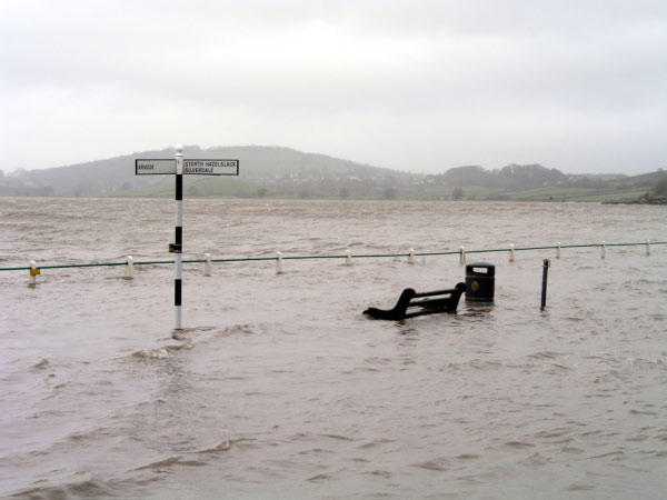
I’m aware daily of high and low tides. The photo shows the T junction at the bottom of my village road as it joins the ‘B’ road next to the River Kent estuary [note the park bench].
(C) Storth Gallery 2021 [this photo replaces one on original posting]
This happens particularly with a spring tide after heavy rains causes a surge in the river. Last winter the emergency services had to rescue a poor old lady who tried to drive through the flood and her car floated and crashed through the barrier to join the estuary [such is the power of moving water].
By contrast, at low tides this summer I have been able to walk across the wide sands and wade across the narrow ‘deep’ channel to the north bank with water below my knees.
Know it well… I’d just done Arnside Knott and was trying to get back to civilisation when I got to that bit of the road and it was under water with a noticeable tide incoming. Only just got through, turned right up the hill and made it back safely.
I don’t know what would have happened if I’d tried to wait it out… probably the locals would have pounced on “freshmeat” and stolen my body and I’d have been pickled and salted and kept ready for a Christmas Feast. They’re a funny lot in these small villages, I’ve seen League Of Gentlemen so I know
Quite apart from seasons and tides the “mean sea level” surface is very far from flat. It has large ripples with amplitudes to tens of metres. The Ordnance Surveys of GB, NI and Ireland, in common with equivalent national and provincial agencies around the world, have networks of geodetic / gravimetric references stations – not just the one. These, in combination with space-based gravity measurements, serve to tie together:
The coordinate systems used locally
Global coordinate systems
The global ellipsoid
The gravitationally-defined geoid – this is the ripply 0-m surface
So it’s more complicated than having a single zero point.
Changes to the way interpolation was done between these datum points that were made in the previous decade lead to significant changes in quoted elevations, especially in the Hebrides. The geiod / ellipsoid offset is a much bigger effect than the post-glacial bounce, at least with respect to human life times.
But like I said it mostly isn’t an issue as in most cases (possibly all) summits that by chance might fall into a problem category actually have their col near enough that the correction is too small to matter. In fact we routinely use elevation data in ellipsoidal height as part of our summit-searching process even though the elevations typically look plain wrong when compared with actual maps.
Indeed. It’s actually something I’m concerned with in my day job – whether to store positions to our database that are tied to GDA2020, which therefore shouldn’t change with time, or to use WGS84 / ATRF2014, which of course do change as Australia wonders about. At the end of the day I need WGS84 anyway, as the astrometric calculations use it, but I think it might be kind of annoying to have to keeping updating the database.
A grace zone…
I’d say that formally SOTA doesn’t have one. A measurement of P < 150 m is a measurement of < 150 m, full stop, regardless of the error.
Having said that it’s understandable to seek more confidence in one direction or the other when adding / removing summits. Say for example somebody makes an “old school” prominence measurement using an Abney level or somesuch and they tell me it’s 105.1 m ± 5 m. By their “best guess” it is actually a valid summit but really it’s a bit of a toss up and almost as likely to be a bad summit. I’d be inclined to ask for improved data, as I’d prefer not to add a summit only to have to remove it again a short time later. But if we had accepted a summit but then later found it had P = 149.9 m ± 5 m it would be natural to seek greater confidence before removing it, because nobody likes to lose a summit.
Of course with GNSS and / or LIDAR such measurements close to the limit become much more meaningful and I’d happily take 149.7 m ± 0.3 m as a reason to retire the summit. But people are attached to their Marilyns and if RHoB want greater confidence than this before de-listing a summit that’s fine by me. But in the case of Cheriton Hill it’s gone from pretty confident (GNSS only) to very confident (GNSS and LIDAR) keeping it listed would be wilfully ignoring the evidence.
And just to add that activators of Mount Stromlo, VK1/AC-043, may well have noticed the Geoscience Australia satellite LASER ranging facility there. These provide an important link between satellite orbits and the ground, vital for all sorts of things.
I wonder if there are any more of these on SOTAs elsewhere?
I conceded my ignorance on the topic previously but don’t see in what way I have missed the point. Wikipedia says, Precise determination of a “mean sea level” is difficult because of the many factors that affect sea level. Instantaneous sea level varies quite a lot on several scales of time and space. This is because the sea is in constant motion, affected by the tides, wind, atmospheric pressure, local gravitational differences, temperature, salinity, and so forth.
Yes, I don’t think I said anything to contradict this.
I was referring to the particular [historical] MSL in Cornwall which I understand is still the single reference point (Ordnance datum) for all UK maps or at least all OS maps.
Yes, it took them years to establish the Newlyn datum – not easy.
It’s not used any more. OSGB map products do still use the old OSGB36 coordinate system and the Newlyn datum (ODN) for presentation. However, nowadays these are defined in terms of ETRS89 (Europe-fixed version of WGS84) and a geoid model to convert GNSS ellipsoidal heights to ODN. Note that ODN only applies to the mainland. OSGB36 refers to the retriangulation of Britain made between 1936 and 1953.
If I understand the history correctly, having established the Newlyn datum they then set about creating the network of benchmarks across GB, literally using spirit levels. It’s quite remarkable how accurately this was done, but nevertheless there’s a bit of a tilt in it and the errors can approach 1m (quite apart from problems arising if your local reference benchmark has been subject to subsidence!). The benchmark network hasn’t been maintained for about 50 years.
I think even more remarkable is that the original 18th century Principle Triangulation only got the length of Britain wrong by about 20 metres. That was based on a single length measurement across Hounlow Heath in 1784 using 18-foot glass rods. Amazing really.
So whilst ODN is still there on the maps, it’s really just a mathematical artefact. Accurate surveys would typically use a modern coordinate system (one where the geoid hasn’t got a built-in tilt), and like Rick said up-thread your GNSS survey instrument would let you choose which. But you’d probably be doing some post-survey work-up with OSGB software anyway. RHoB often give details about this in their survey reports.