SMP main page enhancement

Hi Rob,
I’ve found another minor glitch I think. Summits that have not yet been activated (i.e. zero activation count) are appearing with a grey coloured background not the colour indicating the number of points that they are worth.

Also OE/TI-670 which will be removed at the end of this month 31st Dec. 2015 doesn’t have the red ring around it.

73 Ed.

Not a glitch, but a conscious decision on my part to colour them differently, in order to make them stand out from the rest. In a different type of application, I might have coloured them red, but that colour is taken by 10-pointers; so grey=untouched seemed like a good alternative.

[quote=“DD5LP, post:35, topic:12176”]
Also OE/TI-670 which will be removed at the end of this month 31st Dec. 2015 doesn’t have the red ring around it.
[/quote]Thanks for the heads-up there, I appreciate it as always. I would, however, appreciate it even more if such reports were to contain a little more information to help me to quickly locate the error. Something like this, maybe:

When using the range page to find summits within nnn kilometers of XXXXXX, I notice that the summit OE/TI-670 - which is due to be removed at the end of this month 31st Dec. 2015 - doesn’t have the red ring around it.

I would guess it couldn’t take much longer than a minute more to gather one’s thoughts and write a report like that. On the other hand, I’ve just spent 1 1/2 hours trying to narrow this thing down to the point where I understand WHERE and HOW you’ve noticed this discrepancy, and to be able to explain it.

So to the explanation: the summits OE/TI-670 Zwölferkopf and DL/AL-166 Zwoelferkopf are one and the same summit, which is presumably the reason why one of them has to go. When one views either of the ranges OE/TI or DL/AL individually in the main page, one doesn’t notice that each of these two “summits” actually occupy the same place in the map. In the range page, however, one can see this: look very carefully at the OE/TI-670 Zwölferkopf circle marker (zoom in as far as you can go), and you should be able to see a slight overlap between a light blue circle (DL/AL-166) and the red-ringed circle (OE/TI-670). Testing on my local machine, the latter appears to overlay the former, whereas in the live site, it’s the other way around: but that’s just the Google maps engine, in slightly different environments, trying to decide which of the two (with identical latitude and longitude) to place before the other.

So, the red-bordered circle marker IS correctly displayed for OE/TI-670 Zwölferkopf, but it is (or can be…) obscured by another circle marker at exactly the same location.

EDIT: the same situation of overlapping circles can be seen with the summit combinations DL/AL-046 Ponten == OE/TI-449 Ponten, DL/AL-049 Kuehgundkopf == OE/TI-652 Kühgundkopf, etc.

HTH, Rob
Rob,

So, dziękuję bardzo, and if you make the beer a piwo żywieckie, I’ll be doubly pleased :wink:

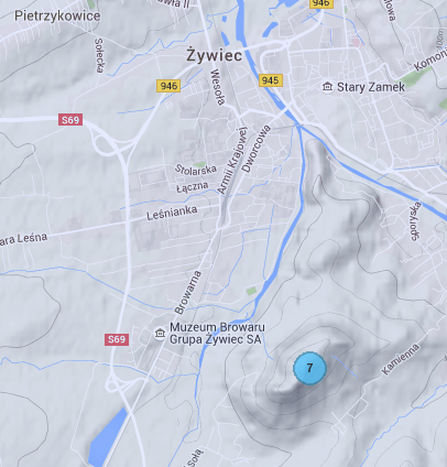
Anytime! Thanks to sotamaps.org I noticed there is a SOTA summit, SP/BZ-077 within walking distance from Żywiec Brewery, so we can combine the beer degustation with an activation, a win-win scenario for me.

That is, if you were willing to make the trip someday. Otherwise I’ll bring a few bottles with me to Wackersberg the next time I’ll be going that way.

Cheers!
Marcin

OK, understood - and good logic there. For me the not yet activated ones are the most attractive to activate irrespective if they are 1 point or 10.

Sorry, you’re right more information would have been easy to supply. The reason Zwolferkopf in the Tirol region (I suspect I have seen another Zwolferkopf in a different region) is beacuse it is a dual-summit i.e. one with two SOTA codes defined. I was ONLY looking at summits in the OE/TI region and hence the DL/AL-166 summit didn’t appear (I was not doing a range this time). So the overlapping rings is not what caused the issue.
Unless you have changed something else I think it must be something in Google mapping because I just went back to make a screenshot and the ring is now correctly displaying. Thanks for updating the key as well by the way.

Ed.

sounds tempting! - but I’ll have to wait until I get a new(er) car next year - my 1996 Audi A4 is slowly rusting away!

[quote=“SQ9OZM, post:37, topic:12176”]
Otherwise I’ll bring a few bottles with me to Wackersberg the next time I’ll be going that way.
[/quote]Any time!

Vy 73, rob

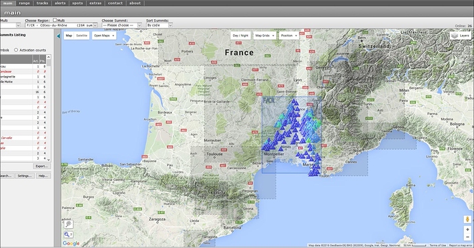
So, a new enhancement has been introduced into the SMP main page - when one chooses a single region from the top controls, the region is displayed, as before, with a border-rectangle and the summit icons, but now also displays any nearby regions as pale rectangles with dashed borders.

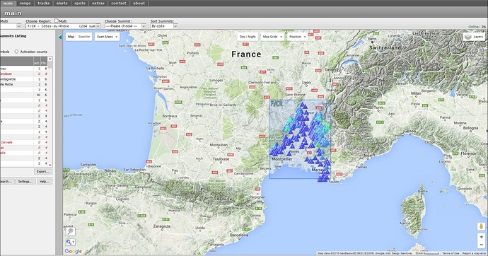
These nearby regions are defined as those having any summits which are within 2 degrees of latitude or longitude of the furthest extents of the current chosen region. So, before this new enhancement, one would have seen something like this:

where the single chosen range is shown on the map. The new enhancement, as described above, displays any nearby regions as here:

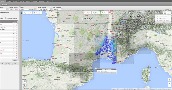
These nearby regions rectangles react to the mouse passing over them, to show a small infobox displaying the region code and name as here:

By double-clicking when the mouse is over any nearby region rectangle, that region and its’ summits will be loaded as the new chosen region and again a new set of nearby regions will be displayed around that chosen region.

For those who do not wish to view nearby region rectangles, either sometimes or never, a new “Layers” map control has been introduced at the top right-hand corner of the map area. This can be used to toggle the visibility of nearby region rectangles, as well as the main region rectangle and/or summit icons.

An example of a good reason for switching off the display of nearby regions rectangles - at least temporarily - would be if one were to use the “Measure S2S distance…” control at the bottom left-hand edge of the map area, since the nearby region rectangles can interfere with the mouse being able to register when it’s hovering over a summit icon. That’s not a bug, just an inevitable consequence of a multiplicity of objects sharing screen “Z-space”, plus limitations imposed by the Google maps API layering of objects.

The other SMP map controls at the top of the map have also been updated for better look/feel and functionality.

That’s all for now, folks!

Rob DM1CM

7 Likes

What a great feature - especially when looking to activate a summit close to the edge of a region, it may be possible to activate an additional summit in the next region that is close by in the same trip. When only looking at one region, you might not realise that the summit in the neighbouring region is very close, so being able to simply click on the other region to see its summits is a very nice capability.

Ed.

Hi Rob,

Is there a way to disable this new feature permanently and only switch it on when needed?
It is great to have but it makes the map download terribly slow :sleeping: - at least with the Internet speed we have available at our QTH…
I tried to disable it via the Layers control but I can only do so after the map has built up and the setting does not stay, i.e. I need to wait and do it every time I open the mapping project.

73, Sylvia OE5YYN

1 Like

Hi Sylvia - thanks for the heads-up: I’ve started working on a solution to this problem, shouldn’t take too long :wink:

Rob

OK Sylvia - and any others out there who are interested in this feature - I’ve now updated the code to permit the user to:

  • enable or disable the display of any nearby groups;
  • choose the extent in latitude/longitude (between 0.25 and 2.0 degrees) of any nearby groups to be displayed (the greater the extent, the more groups will be displayed if enabled). Neither of these options are saved in cookies, so would need to be set each time the page is refreshed. I try to keep use of cookies to an absolute minimum, but this policy may change soon…

The above options are to be found in the main page settings dialog, which is opened by clicking on the “Settings…” button in the lower left-hand part of the page.

In addition, the (SMP-local) database structure and SQL codes have been altered to permit much faster loading of nearby regions when they are enabled.

Hope this helps,

Rob

2 Likes

It’s a great pity that you don’t run the WSPRnet GIS Rob. Their site has needed a makeover for many years and the SOTAmapping site is light-years ahead.

Richard, I take it you mean Map | WSPRnet ? I wasn’t aware of this site, but the page doesn’t look too bad to me…

Hi Rob,

Thanks a lot for the prompt reaction and the solution to the problem!
Funnily enough, today, for the the first time, the map build-up was only a matter of a second :wink:

73, Sylvia

You’re welcome!

Well, that’s because…

That’s actually the solution right there: the rest is just icing on the cake :

Rob

Typical of me, didn’t read till the end of the answer :blush:
:clap::clap:
Much appreciated!

73, Sylvia

While on the subject of the Settings dialog in the main page, I noticed today that the options to set the Region box colors and opacities was also not working. So, for the 1.5 people in the world who actually use/used that option, it’s been fixed and is now working again… :grinning:

Rob

1 Like

Hi Rob,

Very neat. Very Timely. I’m looking to activate a peak in VK3 in 8 days and one of my selection criteria is number of time activated.

Good work.

73
Ron
VK3AFW

Hi Ron - I suspect you’ve only read the first couple of posts in this thread, where the option to display summits as triangles or as activations-count circles was reported in December 2015. There are other, newer, goodies reported in the thread, too…:slight_smile:

Rob

Hi Rob,

Yes,

I saw an update and inadvertently went to the earlier post. Now whether I missed it at the time or it’s Alzheimers I don’t know but it was new to me and most timely. Yes i’ve seen the other improvements.

Don’t know where you find the time. Great work. Thanks.

73
Ron

Hi Rob,
Can you please consider making the new features (neighbouring regions etc) disabled by default and then have the user turn them on via the settings option, rather than the other way around. I for one find that most of the time I just want to see only the summits in the region that I am have selected. If I find I am near the edge of a region, then I may turn on the new features to see if there are any close by summits that I may want to include in a multi-summit activation trip.

Thanks Ed.