Initially P = 149.83m from hours of data collected with Leica instruments, then allowing for the ionosphere, with post-processing, this came up to 150.7m. Nice!
Andy it’s only about 8.5km to the nearest road. If the summer-only ferry over the Kyle of Durness runs there’s a track that gets you within 6km (as the crow flies).
A race to get there before one of those knocks >0.7m off the top
Edit: Doh! that’s what comes of hasty late night posting - it would, of course, have to add >0.7m to reduce the prominence. Too late to delete now, though…
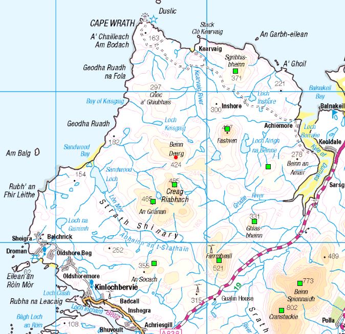
That is tricky to get to… doesn’t really fit in with Creag Riabhach and An Grianan which are quite conveniently done from Strathan Bothy nor the Cape Wrath Three. A bit of research and planning needed :-s
Don’t rush to update GM Andy still need to grab Cruim Leacainn before it’s consigned to the SOTA has-beens…
Isn’t the situation that until the summit (in this case Beinn Dearg) is registered in the SOTA database, it doesn’t count as a SOTA summit? So until you register this new one it’s not a SOTA summit even though it “just” meets the P150 criteria?
So anyone looking to activate this summit needs to plan their activation to occur after you have added the summit and a reference code has been allocated.
Bearing in mind the distinction between precision and accuracy, and with the new Marilyn only 0.7m above the minimum height, I wonder what the confidence limits are?
The height data for the col and summit is gathered with a survey grade GPS. This not only calculates your position accurately it records the data received from the individual GPS satellites. Once you have gathered all the data, post processing occurs using data from fixed OS reference stations. These stations are at defined positions and can calculate errors in GPS derived position. This data is used to correct for tropo errors in the inflight GPS data streams. Finally the satellite orbital data is used to ensure the data sent from the satellites is corrected for orbital perturbations.
The Leica GPS units with post processing and long observations (the case here) give accuracy in horizontal positioning of 3mm +/- 0.1ppm and vertically 3.5mm +/- 0.4ppm. So yes, there was sufficient data of sufficient accuracy of suitable traceability to give a col to summit difference of more than 150m.
That’s so cool. I didn’t get why you would need ‘Ionospheric’ post processing initially, but I do now - thanks for the explanation
Clearly the tolerance is fine in this case, but just like F1 finishes, I bet there is a hill out there where a couple of pebbles are going to make all the difference
Yes, a valid point it would seem. However, it ignores the fact the people doing these measurements have a significant degree of clue about what they are doing so that it is all traceable and repeatable and not open to simple influences.
I’m quite prepared to concede their competance, Andy. What raised a nubbin of worry was the size of the ionosphere allowance in proportion to the claimed precision, since we know from experience how variable the ionosphere is. Still, my experience of surveying was back in the days of theodelites, and level and staff work, and things have moved on a long way!
I can’t recall which, but during the late 1800’s there was one magic mountain in Scotland which was just short of 4000’ so they tried to raise it to the 'required height by making a large cairn on the top.
IIRC, that was Ben Lawers. Rather amusingly story - about 30 years ago I went into the tourist office in Aberfeldy and fell into conversation with the guy running it. In the course of our chat the topic of mountains came up, and he told me straight-faced that the highest mountain in Scotland was Ben Lawers. I said that I had heard it was Ben Nevis, but he answered “Och no, that’s a common mistake!” Local pride, I guess, I didn’t argue - it would be like arguing with a Brexiteer or a Trump supporter!