I will be some days around Kerry end of december / first week of january.
Our hotel is in Killarney.
I am not sure if I will rent a car or not. That depends mostly on how good public transportation is there.
As I have the YL with me, I can not do extensive hiking. I wonder if there is any easy summit around and is there any reachable with a train or bus?
How is 2m FM only from SW EI? Anybody there or is my FT-817 a must?
No regular public transport except between towns and from memory infrequent. Plenty of taxis though. From memory its a longish walk to get to any hill from Killarney town.
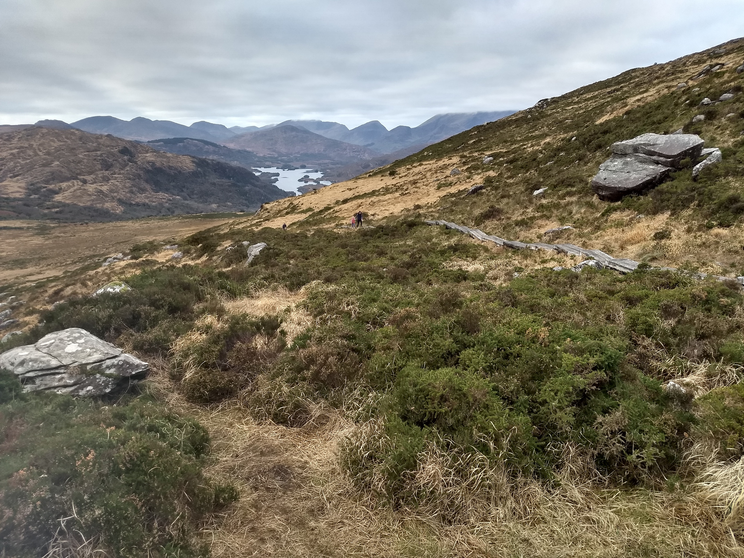
Killarney is within easy reach of the MacGillyCuddy’s reeks, a spectacular range of mountains equal to anything in the UK and some knife edge ridges too. They do get snow sometimes, but I wouldn’t worry about winter kit such as crampons and/or ice axe as it rarely lasts and rarely consolidates.
Buy the OSI (Ordnance Survey Of Ireland) map number 78 which covers the Reeks and Perhaps 79 which covers further the east. These are good maps at a scale of 1:50 000 and should be easily available when you arrive if you haven’t already bought them on-line.
And regarding the use of VHF…
Although I haven’t tried it in that area, I have struggled in other areas of Ireland (NW, W coast and even the east where all my 2m contacts eventually came from NI). I suspect you might struggle. At the very least use alerts and spots and definitely a better aerial than the standard HT version.
HF would help! Good luck
You might need a hire car as public transport is patchy at the best of times and particularly so over the Christmas/new year period. You could do Torc Mountain EI/IS-050 with a Taxi ride from Killarney? Mangerton EI/IS-006 is also possible by taxi. This is a bit more challenging, but possible if you are very lucky with the weather.
HF is a must - there is virtually no 2m activity in the area.
I will be active myself from 29/12 to 04/01 on the Beara Penisula, West Cork, just south of you. Hope to hear you - maybe S2S.
I was also impressed what I looked on SOTAmaps. Did first book and then looked into the maps.
Thank you very much for this info.
Rather then checking in a big 2m Yagi I take my FT-817. I only have my cabin luggage and nothing checked-in, so I hope Ryanair will make no problem.
Alright, will do that. Was a bit scared as you drive on the wrong side over there. Did it in London about 10 years ago and I think if felt a bit strange back then.
Sorry to ask, but when I have my rental car: Do you have an advice in an hour driving distance around kerry for an easy summit? Last time I asked for an easy one in the alps we had to hike a whole day. The YL always find holiday with SOTA a bit suspicious. LOL
I am arriving Kerry airport Dec 31 and will leave Jan 04 early morning. I will check the map but with my rental car maybe there is a chance to meet somewhere.
Thank you guys for your help.
73 from Germany
John, DK9JC
I think you’ll find that County Kerry in December is not as stressful as London for driving on the wrong side of the road!
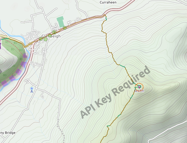
The Killarney area probably has the most difficult summits in in Ireland but there are some easier ones too. Torc Mountain EI/IS-050 looks to be reasonably straightforward. Adrian G4AZS has posted some notes on this one. A little bit further away, near Glenbeigh are EI/IS-108 Curra Hill and EI/IS-059 Seefin which should also be very easy. Bentee EI/IS-084 near Cahersiveen is pretty easy too, but from memory, a bit boggy. Bray Head on Valentia Island EI/IS-117 is spectacular on a clear day. I can recommend the excellent www.mountainviews.ie for access and parking information on EI/GI summits.
It would be great to meet you while you are over here. Kenmare, on the tourist route, looks to be about half way between our holiday bases? Just need for the wx to improve - it’s a constant diet of Atlantic fronts at the moment. This weekend looks like another write-off over here!
Yeah, this is what I thought when I checked OpenStreetMap. I saw you have also been to FL/VO. Can’t compare…
We are going primarly on a new-years-eve trip, not a SOTA holiday so the YL let me only do one summit.
Yeah I think it is most probably the one we will try.
I saw his notes. Very helpful. I do that all the time here in my region and I would love to see more people doing that. Great info.
Thank you, I checked them out. EI/IS-108 Curra Hill is definetly on the list. For EI/IS-059 Seefin I do not find tracks or paths on Open Street Map. I try to avoid to get lost there.
Not with the YL… That would end soon… Had that experience once with @DB7MM while the YL was joining our actication…
Ok, very nice. Looking good one the map and seems to be pretty easy though.
With the rental car that should be no big deal. We are still doing some plannings and I will let you know then.
One last question. I fly with check (hand-)luggage one. I can not fit one of my travel masts in there. Is there any chance to fit the antenna wire (ultra thin, 0,14mm²/35 AWG) somewhere? Otherwise I have to try get a painters-pole or something in a local store.
If you check out Seefin EI/IS-059 on Mountainviews.ie and click on the summit marker, you can bring up all the hiking reports and tracks…
I doubt if you will find much to hang a wire from on any of these summits. Almost certainly no trees. I guess you could try to buy a painters pole or a fishing pole. If you’re stuck, you’re more than welcome to borrow one of mine. I mainly use a 10m DX-Wire travelmast but I’ve got some spares, including a WIMO 6m compact travel mast and an ultra-compact 4m one from Sotabeams.
I just did it for Seefin. Thank you. Much less info on Openstreetmap than here. Here in Germany that is all you need.
I just went to my local Decahlon store and bought a ultra-slim mini fishing rod (Lakeside-5 Travel 500: Stipprute Lakeside-5 Travel 600 CAPERLAN - DECATHLON) which just fits into my luggage. The rod contains 57% carbon, so I am curious if this makes any difference to my fibreglass ones. Still need to make any kind of guying-system, here in DL I just fix the rod to signposts or small trees.
Thank you for your offer. Highly appreciated. If my new rod works I do not need to do that.
This is what I usually carry with me. Bought at the HamRadio in Friedrichshafen direct from the owner, Peter, DK1RP. Had a problem with the lower cap, was fixed in no time with great support btw.
Okay guys I am leaving tomorrow towards EI.
If I get no problem with all my radio stuff in my cabin luggage I will do Torc Mountain EI/IS-050 535m, 6 Points [+3 extra for winter bonus] either Tue 1st, Wed 2nd or Thu 3rd Jan 2019.
Close to Torc Mountain we will check out Torc Waterfall and Muckross House.
I also like to see a Whisky Distillery and only found Dingle Distillery. If I am in that area anyway I might do EI/IS-127 Carhoo Hill 184m 1 Point and / or EI/IS-106 Knocknanacree 286m 1 Point which are just around the corner from the distillery. I know this is just a bit off-topic but does anybody has a recommendation on Whiskey somewhere in the southwestern part?
Backup summits are: Bray Head EI/IS-117 239m 1 Point and / or Geokaun EI/IS-112 266m 1 Point both on Valentia Island.
I wonder if there is mobile phone network available. As I am a roamer, I can access all carrier. Here in DL I always carry a FT2 with APRS so I can spot when I have no network. I might carry that in my bag too.
I can’t help with the Whiskey (hate the stuff), but a quick update on the wx. Looks like it will be cloudy, mild (10C), with light winds, no significant rain, just some occasional mist.
Cloud level is quite low, so you may not get great views. I activated Carran EI/IS-042 604m on the way down here yesterday in very foggy conditions (compass/gps essential)
There should be no problems with phone coverage on any of these summits. Hope you have a safe trip.
73 John
.
Hi John,
thank you for the info especially for the wx. Just made it through the security with all my radio gear. So expect me to be qrv from Torc Mountain tomorrow.
Hope to catch you on air.
73 de John DK9JC (now boarding for EI in Frankfurt-Hahn)