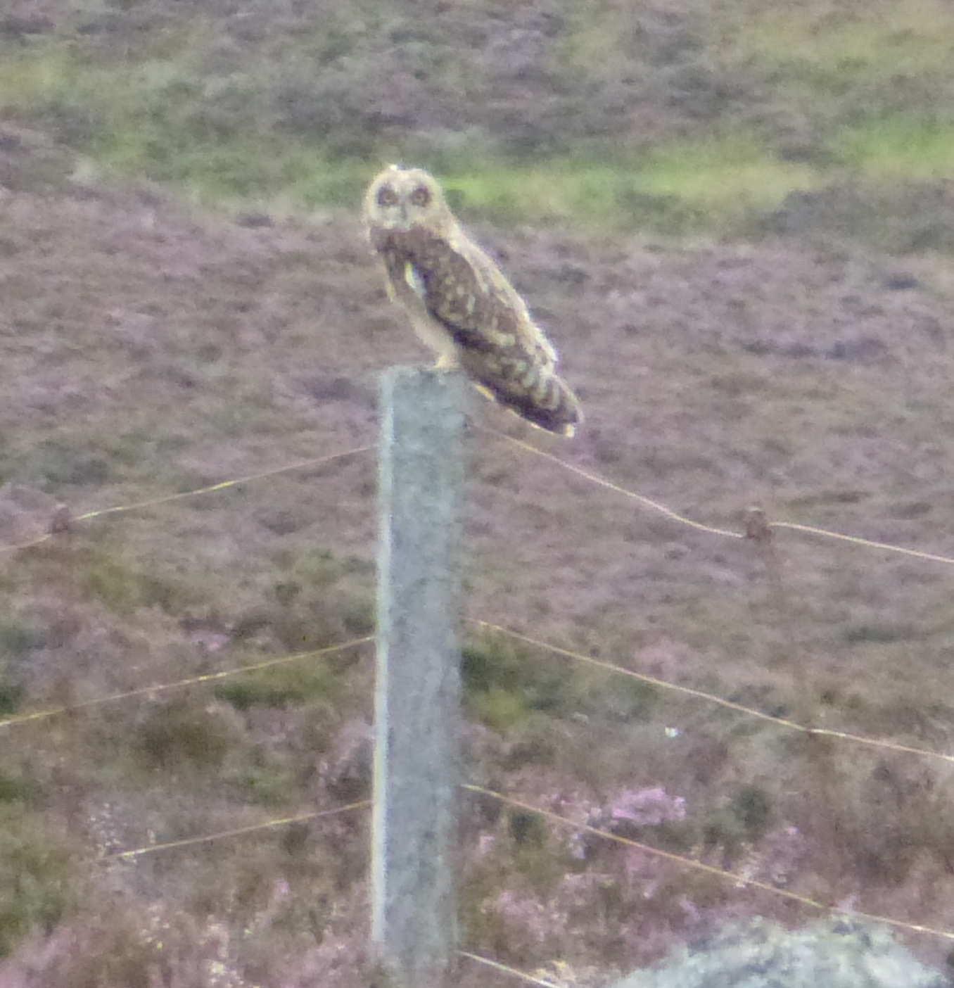
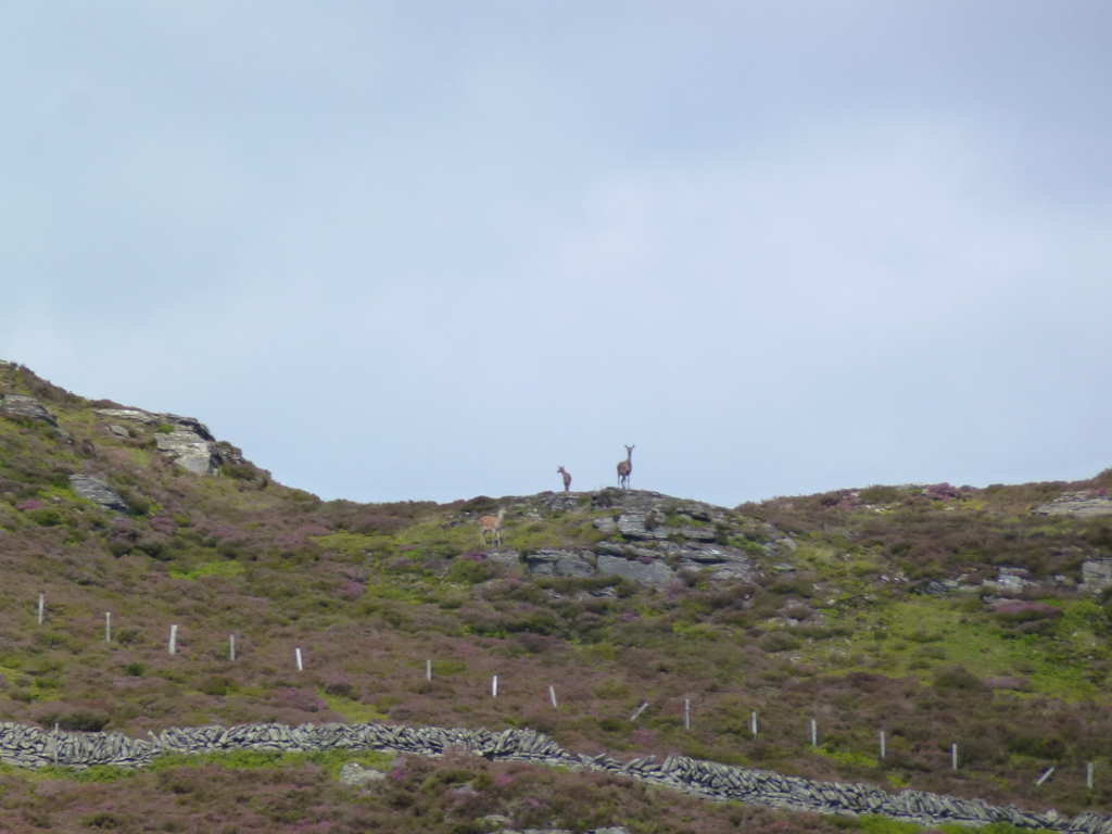
There’s a reason this summit is not activated very often… it’s a long walk from anywhere. I’ll write up the gory details tomorrow but I wanted to share this photo. It’s not the best because the camera was zoomed to the max and everytime I tried to get near it flew to the next fencepost. I knew it wasn’t a Red Kite or a Buzzard from how it flew but I only saw what it was when looking at the photos.
5 Likes
Short eared owl?
Brian
What a hoot!
Good one Andy. And good to get this new one for me on 10M. I had been chasing you up from 30M and ten was the only one that worked. I was using my 10M sloper. Where you operating a verticle?
73
Jack(;>J
Bird maybe? 
Matt
VK1MA
Yes, a internet search about owls would agree with you Brian. It’s one of the owls that hunts during daylight and the hectares of moorland than surrounds Creag nam Mial is typically where you will find the Short Eared Owl. I knew it was some kind of Bird of Prey but it wasn’t what you normally see, a buzzard, kestrel or Red Kite. It may be typical Short Eared Owl terrain but it’s the first time I’ve seen one in hundreds and hundreds of activations.
I live in a “leafy suburb” with farm land within 100m of my house. Well it used to be farmland, the farmer has grown several crops of 4-5 bedroom houses in the last 10 years ![]() There’s plenty of trees around here (broad-leaf and pine) so we have a healthy owl population.You can hear them screeching and hooting away at night but I’ve never seen one around here. Owls tend to be quite good at remaining invisible normally.
There’s plenty of trees around here (broad-leaf and pine) so we have a healthy owl population.You can hear them screeching and hooting away at night but I’ve never seen one around here. Owls tend to be quite good at remaining invisible normally.
10m was open but with amazing QSB. I could hear an OK and an OM calling at the same time. The OK was OK2PDT/P for an S2S (nice on 10m) and the OM was very QSB. Then I thought it was a DM. Then you were loud enough for long enough for me to hear it was a GM! It can’t have been all groundwave propagation because there’s no real QSB on groundwave. So there must have been some skywave/backscatter involved.
What has me smiling is knowing you’ll want to activate this summit for the complete. Hahahaha! You’ll certainly earn the points on the walk in!
EDIT: yes the antenna was a vertical, my Buddistick clone with a shortened top section for 10m.
Certainly wouldn’t have made it on SSB. And interestingly it appeared you were struggling more with my 60W than I was with your (I suppose) 5W or thereabouts?, and your quiet QRN free environment?
As mentioned there was nowt on the other bands where I was using my 80M doublet - horizontal (of course - hi!) so that’s why I thought it was really mainly groundwave - vertical to vertical?
Good one what-ever-way?
Jack(;>J
PS: for the Complete I’ll have to watch out for any low flying
 - INGS
Aye, but there weren’t any midges in your shack Jack! ![]()
Nice photo Andy. I’ve only ever seen one in the wild. Must do some more GM/CS summits and keep an eye out…
Heck, I even get midges in MY shack when the window is open in hot summers! They might not be the tungsten-toothed Highland variety but I’m still sensitive to them and get little lumps from the bites!
One of the joys of this outdoors lark is that you never know what you are going to see. For instance my first merlin was on SS-065, long before SOTA gave it a number! Incidentally, a short-eared owl hunts near the road on Binsey, LD-041, so its worth looking out for, or at least it did earlier this year!
Brian
Right, here’s the meat of the report.
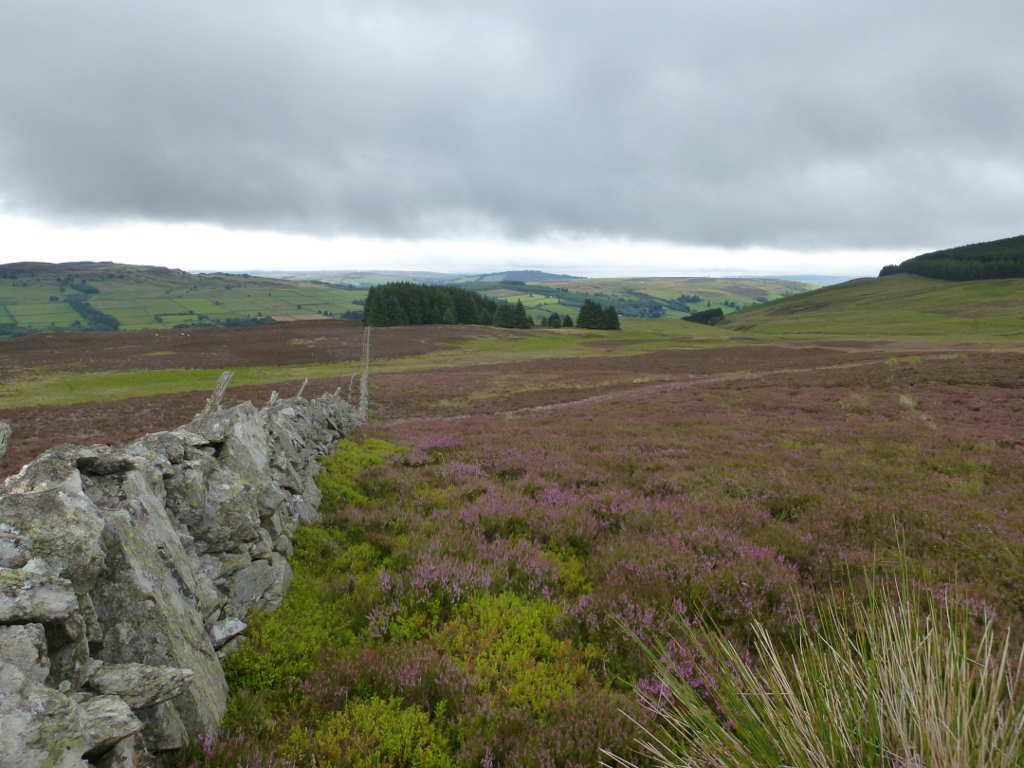
This summit is a minimum “crow-fly” distance of 5km from a public road. The furthest you can get from a public road in the UK is only 10.3km, again a straight line distance with no consideration of terrain or tracks etc. So Creag nam Mial is quite remote for UK summits. Then there is the terrain, every report I’ve read says this can only be approached after crossing seas of waist deep heather. Well it wasn’t waist deep for me. Then when you do decide to do it there’s isn’t anywhere obvious to park! But I see this summit sticking out as something that needs to be done as I slowly work my way through the “local” hills. I did a bit of research and rang a business in the Ballintuim area and got permission to park on their land, first obstacle overcome.
You really need the 1:25000 OS map to decipher the tracks, but from the phone box in Ballintuim, make you way to Woodhill Farm. There are plenty of signs, follow “Keeper’s Cottage” then when you see a sign “Trail” follow that. This brings you to the Cateran Trail, a long distance path. Turn right and follow the trail a few hundred metres and when the path splits, go left and uphill. If you reach a deer gate into woods you have gone too far. Follow the track uphill as it zig zags. Pass the ruins and as the ground levels out and path peters out (it doesn’t on the map, hahahaha!) head straight for the small copse in front of you. This field has plenty of cattle in it, females with a few calves, use you skill and judgement in how to cross a field of cattle. (Contains Belted Galloways, cows with the same colour scheme as Giant Pandas, they have a reputation for being nasty, I gave them a WIDE berth.)
At the gate by the end of the copse you have complete about 2.5km of decent tracks and ground and half the ascent. It’s diabolical from here! There is no path for the next 4.5km and there is essentially nothing but heather. Some was ankle deep, some was thigh deep, but essentially nothing but heather. Oh that’s apart from the boggy bits. Now a long time ago Brian G4ZRP told me you nearly always find a path of some kind by a fence/wall made by animals. They walk back and forth looking for somewhere to cross. So that gives you 2 choices from the gate, head basically North to the drystone wall that you can follow all the way to the summit. Or head basically South to the other drystone wall that leads to the summit. Either way make a decision because across the gate the ground is very wet and soft. I went North and as the ground rose a few metres it got better. It was still horrible, just less horrible.
There was a bit of a track by the wall and the plan was to follow it to the summit. So it began… a never ending toil against awful ground and vegetation. What is surprising is how tiring it is walking through heather. It meant that the effort needed in climbing the gradient was nothing compared to the effort of moving through the undergrowth. It was a relentless effort. Now the WX was meant to start of very overcast and it was with leaden skies. But it was meant to improve. It was also meant to be very windy at it wasn’t. There was just enough breeze to keep me cool but not enough to deter the flies. Millions of the blighters and every time the breeze dropped I was mobbed. 
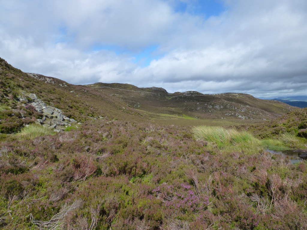
It took a long time to cover the ground to the first shelter. It’s about 700m back to the trees in this photo and I’d expect it to take me 12mins . Well it took nearly 30mins to cover that stretch. You can see what the ground is like and this is the easy stuff!
It was a little further on I saw what turned out to be a Shorted Eared Owl fly from the ground and settle on a fence post. The North route crosses the flanks of Meall Dubh (black hill) and then drops and you finally climb up to the summit. The Southern route climbs to the summit of Meall Dubh then bimbles along the ridge to the short pull to the summit. I was going to come back that way. However, on actually seeing Creag nam Mial, the ground looked far to steep to be an easy ascent with the heather especially as I would be well tired when I got there. It made sense to climb the gentle ascent to Meall Dubh’s summit whilst still fresher and follow the ridge. The ascent would be spread over more distance. So I went South to the summit of Meall Dubh, which was surprisingly easier considering.
It’s quite craggy here and there ar some quite abrupt drops of 10-20m which needed a bit of negotiating. Not hard but you’d be surprised in the mist if not watching your way. By now I had 50% blue sky and the breeze had freshened as it turned into a lovely day. The way here is hardly noticeably up or down but the computer tells me the ascent was 75m and the descent 55m from Meall Dubh summit to Creag nam Mial spread over 1.8km. The route meanders through many rocky knolls and with the now nice weather it was rather pleasant. If only I wasn’t completely knackered by now it would have enjoyed it more. I did find some very good deer tracks here which made the last km of walking bearable.
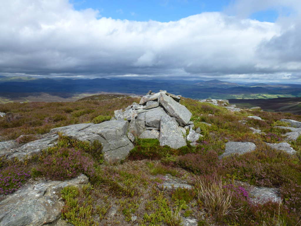
Here is the 1st close-up view you get of the summit from the Southern route.
These chaps and their friends are responsible for creating the decent tracks that exist up close to the summit. You can also see the stone walls which run for miles and miles around here. Someone had some serious money to pay to build them.
As you get to the bottom of the final ascent you can see a substantial shelter. Maybe it was for shepherds but the scale of the heather suggests it’s a long time since sheep or cattle grazed here.

By the time I got to the top the predicted wind was blowing. This was good as it kept the flies away. I set up and had a quick tune on 10m, nothing heard but 20m sounded lively. However I thought I’d try 30m first to get the closer in stations. Nothing. I spent 10mins calling for no reply. I wondered if maybe RBN had not heard me, out with the phone and I had almost a full strength HSPA 3g signal which was a big surprise. I could see Mount Blair which sports a big comms mast so I assume the signal came from there. I had been spotted but there were no takers. On to 20m and it was nice to find the band somewhat alive and I had no problems working 22 stations. ODX was KA1R but by far the best signal was CU3AA who was so much louder than everyone else. Smashing signal Joao. After that it was 10m where I had 5 SSB contacts from a self spot and a bit of search and pounce. Then a CW self spot and another 5 stations worked, mostly Poland but with Sweden, Germany and Czech Republic. Plus the contact with Jack GM4COX at 104 km. Ground wave, or sky wave plus back scatter? Who knows but it was another for the challenge. I could hear a few weak 6m signals but not strong enough to work and of course the 6m antenna was in the car. Damn!
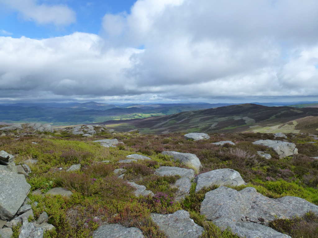
The sky looks dramatic here, but it was hot in the sun. I put my sun hat in the bag at the last minute and was glad I did as I am quite brown today. In this photo Mount Blair ES-035 is the quite obvious dark cone to the right of the cairn in the distance.
Here’s Meall Dubh, I followed the ridge from its summit round to this one.
Looking toward The Spittal of GlenShee.

Apart from a windfarm I have tastefully omitted from view the feeling of remoteness here is amazing. The only obvious signs of man are the walls and fences and if you squint a mast on Mount Blair. Of course nothing is remote in the UK compared with say parts of The Rockies or the Australian Outback. But us here in little old Britain, this is almost as remote as it gets.
Finally here’s Creag nam Mial. The ground is so horrible it took the best part of 40mins to walk 1.25km downhill.

After 1hr40mins at the top I packed up and before setting off had a long drink a chocolate bar, adjusted by boots and set off. Return was to follow the Northern wall back to the gate. Diab-bleedin-bolical is the only way to describe the walk back. I managed to trip over some old rusty fence wire on the steep section descending from the summit and went end over end twice ending up like a tortoise on my back. The only injury was to my pride… falling about 20ft down the hill would normally be serious but with almost waist deep heather there was no damage. It took as long to get back to the car as it did to get up which says the ground was the factor here. It took 2hr40 both ways whereas the computer says it should take just 2hrs.
It was certainly worth it, an obstinate unactivated summit has been removed from the map. Slowly and steadily they’re getting ticked off. I walked about 13.5km but it feels more like the near 20km it is from Spittal of Glenmuick to the summit of Lochnagar and back and that has an ascent of 750m as well! You should see my boots… serious scuffing damage to the toes. Just as well I wore an old pair that have seen some abuse.
The best thing is knowing that Jack GM4COX will have to activate this now for the complete. 
1 Like
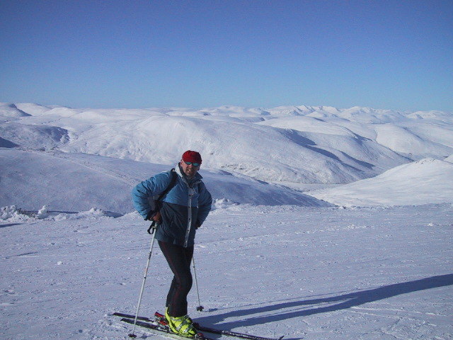
I’ll wait till February when there should be a good cover of snow on all that lovely heather and I’ll just skim over the blighters on me skis ![]() Now wait a minute did I not go and sell them ???
Now wait a minute did I not go and sell them ??? ![]()