Hi Glyn,
This is very useful to know. Thank you for letting us know that you will be speaking to your colleagues to OS this weeks to find us if any access land goes into the activation zone of the new summit, it would be great if it did.
Jimmy M0HGY
Hi Glyn,
This is very useful to know. Thank you for letting us know that you will be speaking to your colleagues to OS this weeks to find us if any access land goes into the activation zone of the new summit, it would be great if it did.
Jimmy M0HGY
To see the work that the RHB put in to summit review, it is worth watching some of the videos at https://www.youtube.com/channel/UCqJhkfCRizie5BxwKTYxImw
The video I was most interested in was https://www.youtube.com/watch?v=YMZd0K8nKGs GM/SS-275 for which I was first activator on 07 May 2005
ISTR the differential GPS units that they use can be obtained second hand for around £8000
Jim
It looks as though this might be the case Glyn. I will endeavour to take a GPS check when I visit the site, subject to the vagueries of the edge of the OA land as shown on the OS map. However, I have attempted to position the OA boundary on the Google Earth view and this gave me a distance of 210 metres between the AZ and the recorded new summit position. What I find interesting is that the initial view presented by Google Earth is actually January 2005, whereas a newer view can be pulled up which dates from November 2009 and clearly shows the OA land section mostly landscaped. Why is this not the default view?
There is nothing indicating the edge of the OA land on the 2009 view, so I will need to take a careful check of my position if a fence has not been erected. One encouraging aspect though is that the landscaping evident on the 2009 view does not follow the line of the OA land and as such one would hope that eventually the entire area might become OA land.
Gerald G4OIG
Edit: just had a bizarre thought - if I take a rig with me and operate from the OA land ensuring that I am less than 25m above DC-004, then is the activation valid. i.e. does an AZ extend above a summit?
Have you read the rules to see what they say?
Funnily enough I have… and normally the operating position is required to be at or below the summit. However in this case I suspect there isn’t a closed contour 25m below the summit height, on which the definition of the Activation Zone is based… which makes interpretation of the rule veer towards the philosophical… is there an activation zone? Is the current summit valid at all???
![]()
Spoilsport 
Just an amusing observation Andy and a tongue in cheek question posed to see what response I would get… Of course many of my activations are not valid as I levitate by psycho-kinesis while operating. Just ask Paul, he knows I am always on a high.  There has also been the odd occasion when I have been sitting on the fence, so I guess those are equally invalid.
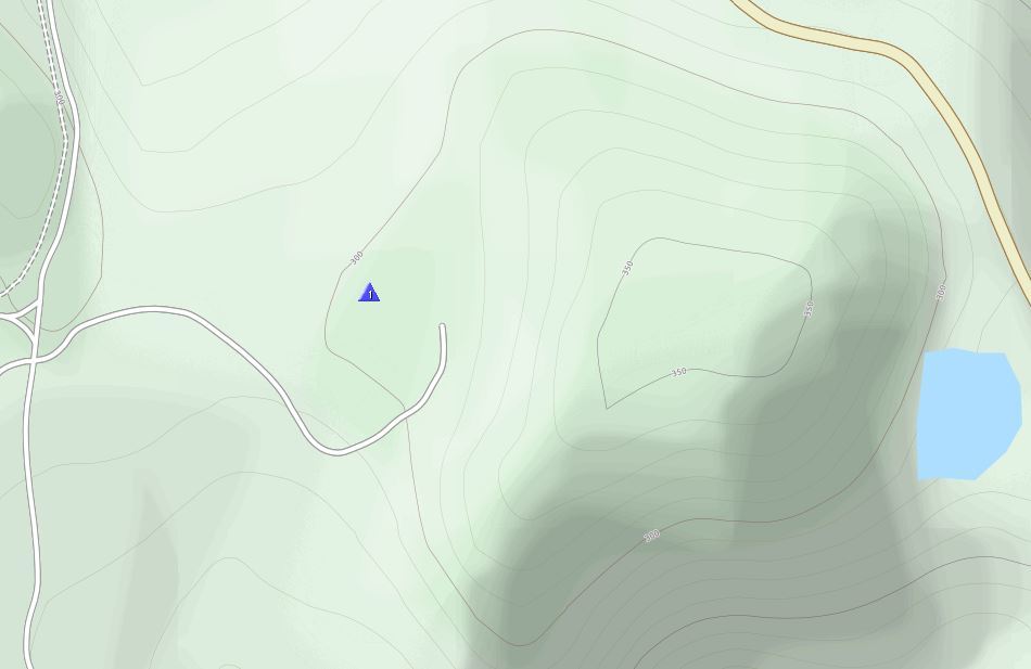
I was surprised there was an OSM view that included contours unlike my OS maps which don’t yet. From looking at the old aerial views and the contours of that OSM data, they’re a reasonable match. Doesn’t look like any of the AZ will be on access land.
The landscaping works are likely to have been incomplete at the date of the aerial view. If the OSM is based on the aerial view, which seems likely in the absence of OS data, it may be that it is inaccurate. A check on site certainly needs to be made.
The OS terrain model (dated 2016) still has it sans tip. RHB guys getting ahead of OSGB again!
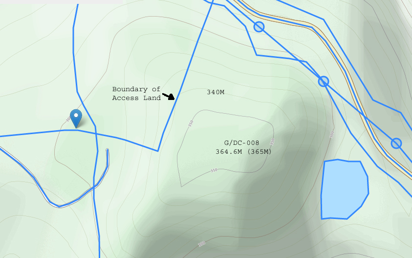
With “Map Data” enabled on the OSM Cycle map the 340M contour just appears to meet the edge of the Access Land in one place.
Of course, the contours are unlikely to be that precise, but it does suggest there could be a tiny piece of Access land within the activation zone, assuming 364.6M will be rounded up to 365M by Ordnance Survey.
The land available may only be the size of an activators foot, if it exists at all 
73,
Mark G0VOF
Now you are giving Gerald hope when you should be confirming he’s going to need permission to activate this one. 
With the access land just looking to be right on the edge of the activation zone and not even accurate the access land does go to the edge of the activation, I would rather just play it safe by getting the permission to access the true summit to make sure I am in the activation to activate this summit. I am hoping the the long term plan is to the all the hill open access.
Jimmy M0HGY
I’m old school enough to have trespassed (harmlessly) on hills that in these more enlightened times are open access, unless it means damaging fences or walls I would have gone for this hill without a qualm. As it is, though, I wouldn’t break SOTA rules. I will be in the area in the spring and hope to do the Beacon, I will suss out the Downs at the same time for another year.
Hi Mark,
That map has contours every 10 metres, so why with the summit at about 365m is there no 360m contour? Perhaps this map is also not up to date?
Ed.
It will be a case of doing a bit of hill bagging style walking back and forth to see where the 340m contour lies and picking up a series of coordinates. I think that will be easier than trying to walk the edge of the OA land and take heights I doubt that they will have reinstated the boundary posts indicated on the OS, if indeed they were not a figment of the cartographers imagination in the first place. Taking the contour route means I will inevitably trespass at some point, but I don’t expect to be hauled up before the beak.
Precisely my view and I rather suspect at some stage it will become OA land.
It is a pity that the rule is not applied on a certain other hill most of us know about.
Perhaps this map is totally inaccurate!
Gerald G4OIG
Executive summary: Open Cycle Map cannot be regarded as a reliable tool to resolve such marginal cases.
The underlying OSM dataset, which is itself essentially crowdsourced largely using consumer-grade GPS, does not contain elevation data. A few isolated points may have “ele” tags of dubious accuracy, but there is no systematic surveying. It follows that no pure OSM rendering can have contours.
The contours that we see in the Open Cycle Map rendering are a separate layer interpolated from NASA SRTM data. I believe this was done in 2008 and may or may not have been updated since; but the key point is that even if other map features appear to be up to date the contour layer won’t be.
Then there is the thorny issue of vertical datums and geoid models. No method such as GPS or radar which measures the shape of the ground, however accurately, can ever tell you height. Height is determined by gravitational potential, and the shape of the ground is only one factor out of many that determine this. The radar data from SRTM is adjusted to be relative to a global geoid model so that it gives a generally good measure of height world wide. However this is not the same vertical datum as we traditionally use in Britain. Ordnance Datum Newlyn was originally determined by a tide gauge in the last century, but has now been redefined relative to the GPS ellipsoid by applying a local geoid model - this model is more detailed than the global model used for SRTM data.This means that we can expect a variable discrepancy between SRTM heights and ODN heights.
Mean sea level in Britain lies below the global average sea level. I have not done the detailed calculations myself, but I have read that the difference is of the order of 5m, i.e. in general we can expect ODN heights to be around 5m greater than the SRTM data would suggest, though the exact value will vary from place to place. Curiously, this is sufficient to explain the absence of a 360m contour on the map you are looking at, though there are so many other inaccuracies in the process that this may be mere coincidence.
I think the conclusion I draw is that Open Cycle Map is not a sufficiently reliable tool to determine whether the activation area and the access area intersect in this very marginal case.
Martyn M1MAJ
Notwithstanding the issue of the sea level datum, it is my intention to attempt to position the 340m contour relative to a known point locally. Ideally this will be the new summit surveyed at 364.6m, but that requires trespass and I will need to take a view on that when I visit the site. The nearest alternative is the summit of Hensbarrow Beacon at 312m. Then we have the issue of where this sits between 311.1m and 312m, given the assumption that Ordnance Survey round up heights, but of course that may not be the case.
Whether or not the AZ actually enters the OA land will be a difficult one to determine with absolute accuracy… How much leeway do we require to be established? Given that the majority of us only have access to a consumer grade GPS, then is it not reasonable to use such an instrument to determine the levels? I would certainly be concerned if the requirement is greater than this, after all how many activations have already taken place from the edge of an AZ using no more than a consumer grade GPS or even an estimation of a height from the Ordnance Survey map? We have to keep in mind that this is only a pastime and our lives do not depend on it.
I will do what I can next week to provide further information on this matter. It would be good to have a clear indication one way or the other, but life is never that simple.
Gerald G4OIG